Cần Giờ geodata
Cần Giờ (Ho Chi Minh) is a seat of a second-order administrative division; located in Vietnam in Asia/Ho_Chi_Minh (GMT+7) time zone. With population of 55,137 people, there are 54 cities with bigger population in this country. Compared to other cities in Vietnam, 85.6% of cities are located further ↑North; 73.7% of cities are located further ←West and 87.1% of cities have higher elevation than Cần Giờ. Note1


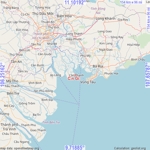
Cần Giờ GPS coordinates[2]
10° 24' 40.14" North, 106° 57' 17.064" East
| Map corner | latitude | longitude |
|---|---|---|
| Upper-left | 11.10192°, | 106.25162° |
| Center: | 10.41115°, | 106.95474° |
| Lower-right: | 9.71885°, | 107.65787° |
| Map W x H: | 153.8×153.8 km | = 95.6×95.6mi |
| max Lat: | 23.27841° ⇑85.6% North |
| Cần Giờ: | 10.41115° |
| min Lat: | ⇓14.4% South 8.65724° |
| min Long | Cần Giờ | max Long |
| 102.4579° | 106.95474° | 112.72541° |
| W 73.7%⇐ | ⇒26.3% E |
Elevation
Elevation of Cần Giờ is 5 m = 16 ft, and this is 124.5 m = 408 ft below average elevation for this country.
| Max E: |
1592 m = 5223 ft | 87.1% |
| Avg. | 129.5 m = 425 ft | |
| Cần Giờ | 5 m = 16 ft | |
Min E: |
-1 m = -3 ft | 12.9% |
See also: Cần Giờ elevation on elevation.city.
Geographical zone
Cần Giờ is located in North Torrid zone (between Equator and Tropic of Cancer). Distance of Equator is 1157.6 km =719.3 mi to South.| Distance of | km | miles | from Cần Giờ |
|---|---|---|---|
| North Pole | 8849.5 | 5498.8 | to North |
| Arctic Circle | 6243.6 | 3879.6 | to North |
| Tropic Cancer | 1448.3 | 899.9 | to North |
| Equator | 1157.6 | 719.3 | to South |


Nearby cities:
15 places around Cần Giờ: (largest is in red/bold)
• Bình Đại
37.9 km =23.5 mi,  229°
229°
• Cần Giuộc
38 km =23.6 mi,  305°
305°
• Cần Đước
40 km =24.9 mi,  285°
285°
• Nhà Bè
39.5 km =24.5 mi,  323°
323°
• Nhơn Trạch
35.5 km =22.1 mi,  347°
347°
• Phuoc Tho
35.6 km =22.1 mi,  75°
75°
• Quận Bảy
41.1 km =25.5 mi, 324°
• Thành Phố Bà Rịa
25.2 km =15.7 mi,  67°
67°
• Thị Trấn Long Điền
29.3 km =18.2 mi, 73°
• Thị Trấn Ngải Giao
41.2 km =25.6 mi,  50°
50°
• Thị Trấn Phú Mỹ
24 km =14.9 mi,  26°
26°
• Thị Xã Phú Mỹ
25.9 km =16.1 mi, 47°
• Tân Hòa
28.5 km =17.7 mi,  248°
248°
• Vĩnh Bình
41.6 km =25.8 mi,  259°
259°
• Vũng Tàu
15.9 km =9.9 mi,  117°
117°
Sources, notices
• [Note1] Compared only with cities in Vietnam existing in our database
• [Src1] Map data: © OpenStreetMap contributors (CC-BY-SA)
• [Src2] Other city data from geonames.org with taken over terms of usage.
• [Src3] Geographical zone / Annual Mean Temperature by Robert A. Rohde @ Wikipedia
