Aş Şalīf geodata
Aş Şalīf (Al Hudaydah) is a seat of a second-order administrative division; located in Yemen in Asia/Aden (GMT+3) time zone. In our database, there are 51 cities with bigger population. Compared to other cities in Yemen, 58.8% of cities are located further ↓South; 100% of cities are located further →East and 100% of cities have higher elevation than Aş Şalīf. Note1


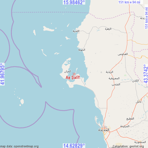
Aş Şalīf GPS coordinates[2]
15° 18' 27.18" North, 42° 40' 15.852" East
| Map corner | latitude | longitude |
|---|---|---|
| Upper-left | 15.98462°, | 41.96795° |
| Center: | 15.30755°, | 42.67107° |
| Lower-right: | 14.62829°, | 43.3742° |
| Map W x H: | 150.8×150.8 km | = 93.7×93.7mi |
| max Lat: | 17.76999° ⇑41.2% North |
| Aş Şalīf: | 15.30755° |
| min Lat: | ⇓58.8% South 12.18576° |
| min Long | Aş Şalīf | max Long |
| 42.67107° | 42.67107° | 54.01895° |
| W 0%⇐ | ⇒100% E |
Elevation
Elevation of Aş Şalīf is 4 m = 13 ft, and this is 1300.8 m = 4268 ft below average elevation for this country.
| Max E: |
2791 m = 9157 ft | 100% |
| Avg. | 1304.8 m = 4281 ft | |
| Aş Şalīf | 4 m = 13 ft | |
Min E: |
4 m = 13 ft | 0% |
See also: Yemen elevation on elevation.city.
Geographical zone
Aş Şalīf is located in North Torrid zone (between Equator and Tropic of Cancer). Distance of this Northern Tropic circle is 903.9 km =561.7 mi to North.| Distance of | km | miles | from Aş Şalīf |
|---|---|---|---|
| North Pole | 8305 | 5160.5 | to North |
| Arctic Circle | 5699.1 | 3541.3 | to North |
| Tropic Cancer | 903.9 | 561.7 | to North |
| Equator | 1702 | 1057.6 | to South |


Nearby cities:
15 places around Aş Şalīf: (largest is in red/bold)
• Ad Durayhimī
85.2 km =52.9 mi,  151°
151°
• Al Khamīs
91.1 km =56.6 mi,  98°
98°
• Al Luḩayyah
44 km =27.3 mi,  2°
2°
• Al Marāwi‘ah
74.2 km =46.1 mi,  135°
135°
• Al Mighlāf
55.6 km =34.5 mi,  92°
92°
• Al Mirwāḩ
83.3 km =51.8 mi,  77°
77°
• Al Munīrah
27.8 km =17.3 mi, 86°
• Al Qanāwiş
53.8 km =33.4 mi,  67°
67°
• Al Ḩudaydah
64.3 km =40 mi, 151°
• Az Zaydīyah
36 km =22.4 mi, 85°
• Az Zuhrah
57.9 km =36 mi,  36°
36°
• Aş Şafaqayn
80.7 km =50.1 mi, 84°
• Banī Ḩujjāj
70.6 km =43.9 mi, 80°
• Bājil
71.7 km =44.6 mi,  112°
112°
• Dhahi
44 km =27.3 mi, 103°
Sources, notices
• [Note1] Compared only with cities in Yemen existing in our database
• [Src1] Map data: © OpenStreetMap contributors (CC-BY-SA)
• [Src2] Other city data from geonames.org with taken over terms of usage.
• [Src3] Geographical zone / Annual Mean Temperature by Robert A. Rohde @ Wikipedia
