Bājil geodata
Bājil (Al Hudaydah) is a seat of a second-order administrative division; located in Yemen in Asia/Aden (GMT+3) time zone. With population of 48,218 people, there are 11 cities with bigger population in this country. Compared to other cities in Yemen, 53.2% of cities are located further ↓South; 93.5% of cities are located further →East and 84.7% of cities have higher elevation than Bājil. Note1


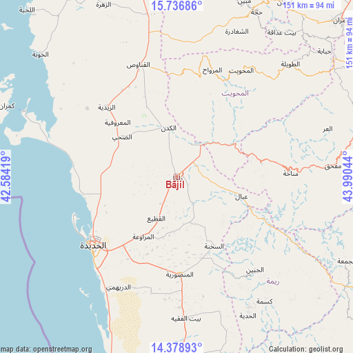
Bājil GPS coordinates[2]
15° 3' 32.328" North, 43° 17' 14.316" East
| Map corner | latitude | longitude |
|---|---|---|
| Upper-left | 15.73686°, | 42.58419° |
| Center: | 15.05898°, | 43.28731° |
| Lower-right: | 14.37893°, | 43.99044° |
| Map W x H: | 151×151 km | = 93.8×93.8mi |
| max Lat: | 17.76999° ⇑46.8% North |
| Bājil: | 15.05898° |
| min Lat: | ⇓53.2% South 12.18576° |
| min Long | Bājil | max Long |
| 42.67107° | 43.28731° | 54.01895° |
| W 6.5%⇐ | ⇒93.5% E |
Elevation
Elevation of Bājil is 191 m = 627 ft, and this is 1113.8 m = 3654 ft below average elevation for this country.
| Max E: |
2791 m = 9157 ft | 84.7% |
| Avg. | 1304.8 m = 4281 ft | |
| Bājil | 191 m = 627 ft | |
Min E: |
4 m = 13 ft | 15.3% |
See also: Bājil elevation on elevation.city.
Geographical zone
Bājil is located in North Torrid zone (between Equator and Tropic of Cancer). Distance of this Northern Tropic circle is 931.5 km =578.8 mi to North.| Distance of | km | miles | from Bājil |
|---|---|---|---|
| North Pole | 8332.7 | 5177.7 | to North |
| Arctic Circle | 5726.8 | 3558.5 | to North |
| Tropic Cancer | 931.5 | 578.8 | to North |
| Equator | 1674.4 | 1040.4 | to South |


Nearby cities:
15 places around Bājil: (largest is in red/bold)
• Al Khamīs
27.8 km =17.3 mi,  59°
59°
• Al Manşūrīyah
41.5 km =25.8 mi,  178°
178°
• Al Marāwi‘ah
29.1 km =18.1 mi,  209°
209°
• Al Mighlāf
27.5 km =17.1 mi,  337°
337°
• Al Munīrah
48.3 km =30 mi,  307°
307°
• Al Ḩudaydah
46.1 km =28.6 mi,  230°
230°
• As Sukhnah
33.5 km =20.8 mi,  151°
151°
• Az Zaydīyah
42.7 km =26.5 mi,  315°
315°
• Aş Şafaqayn
38.4 km =23.9 mi,  21°
21°
• Banī Ḩujjāj
39.9 km =24.8 mi,  4°
4°
• Dhahi
29.1 km =18.1 mi, 306°
• Markaz Bilād aţ Ţa‘ām
36.7 km =22.8 mi,  133°
133°
• Matwaḩ
38.1 km =23.7 mi,  88°
88°
• Riqāb
27.1 km =16.8 mi,  135°
135°
• ‘Ubāl
28.7 km =17.8 mi,  105°
105°
Sources, notices
• [Note1] Compared only with cities in Yemen existing in our database
• [Src1] Map data: © OpenStreetMap contributors (CC-BY-SA)
• [Src2] Other city data from geonames.org with taken over terms of usage.
• [Src3] Geographical zone / Annual Mean Temperature by Robert A. Rohde @ Wikipedia
