Al Marāwi‘ah geodata
Al Marāwi‘ah (Al Hudaydah) is a seat of a second-order administrative division; located in Yemen in Asia/Aden (GMT+3) time zone. In our database, there are 51 cities with bigger population. Compared to other cities in Yemen, 51% of cities are located further ↑North; 96.4% of cities are located further →East and 88.6% of cities have higher elevation than Al Marāwi‘ah. Note1


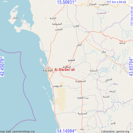
Al Marāwi‘ah GPS coordinates[2]
14° 49' 50.484" North, 43° 9' 14.076" East
| Map corner | latitude | longitude |
|---|---|---|
| Upper-left | 15.50931°, | 42.45079° |
| Center: | 14.83069°, | 43.15391° |
| Lower-right: | 14.14994°, | 43.85704° |
| Map W x H: | 151.1×151.2 km | = 93.9×94mi |
| max Lat: | 17.76999° ⇑51% North |
| Al Marāwi‘ah: | 14.83069° |
| min Lat: | ⇓49% South 12.18576° |
| min Long | Al Marāwi‘ah | max Long |
| 42.67107° | 43.15391° | 54.01895° |
| W 3.6%⇐ | ⇒96.4% E |
Elevation
Elevation of Al Marāwi‘ah is 77 m = 253 ft, and this is 1227.8 m = 4028 ft below average elevation for this country.
| Max E: |
2791 m = 9157 ft | 88.6% |
| Avg. | 1304.8 m = 4281 ft | |
| Al Marāwi‘ah | 77 m = 253 ft | |
Min E: |
4 m = 13 ft | 11.4% |
See also: Yemen elevation on elevation.city.
Geographical zone
Al Marāwi‘ah is located in North Torrid zone (between Equator and Tropic of Cancer). Distance of this Northern Tropic circle is 956.9 km =594.6 mi to North.| Distance of | km | miles | from Al Marāwi‘ah |
|---|---|---|---|
| North Pole | 8358 | 5193.4 | to North |
| Arctic Circle | 5752.2 | 3574.3 | to North |
| Tropic Cancer | 956.9 | 594.6 | to North |
| Equator | 1649 | 1024.6 | to South |


Nearby cities:
15 places around Al Marāwi‘ah: (largest is in red/bold)
• Ad Durayhimī
24 km =14.9 mi,  206°
206°
• Al Jabīn
49.9 km =31 mi,  106°
106°
• Al Khamīs
55 km =34.2 mi,  44°
44°
• Al Manşūrīyah
22.5 km =14 mi,  135°
135°
• Al Mighlāf
51 km =31.7 mi,  4°
4°
• Al Ḩadīyah
56.1 km =34.9 mi,  127°
127°
• Al Ḩudaydah
21.7 km =13.5 mi,  260°
260°
• As Sukhnah
30.6 km =19 mi,  97°
97°
• Az Zaydīyah
57.8 km =35.9 mi,  344°
344°
• Bayt al Faqīh
39.5 km =24.5 mi,  152°
152°
• Bājil
29.1 km =18.1 mi,  29°
29°
• Dhahi
43.7 km =27.2 mi,  348°
348°
• Markaz Bilād aţ Ţa‘ām
41.1 km =25.5 mi,  89°
89°
• Riqāb
34 km =21.1 mi,  79°
79°
• ‘Ubāl
45.5 km =28.3 mi,  67°
67°
Sources, notices
• [Note1] Compared only with cities in Yemen existing in our database
• [Src1] Map data: © OpenStreetMap contributors (CC-BY-SA)
• [Src2] Other city data from geonames.org with taken over terms of usage.
• [Src3] Geographical zone / Annual Mean Temperature by Robert A. Rohde @ Wikipedia
