Al Ḩudaydah geodata
Al Ḩudaydah (Al Hudaydah) is a seat of a first-order administrative division; located in Yemen in Asia/Aden (GMT+3) time zone. With population of 617,871 people, there is 1 city with bigger population in this country. Compared to other cities in Yemen, 51.6% of cities are located further ↑North; 98.7% of cities are located further →East and 97.7% of cities have higher elevation than Al Ḩudaydah. Note1


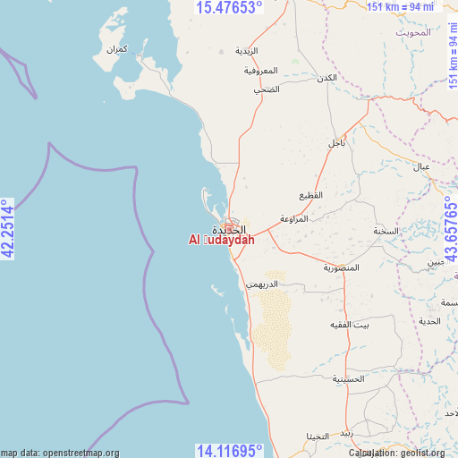
Al Ḩudaydah GPS coordinates[2]
14° 47' 52.116" North, 42° 57' 16.272" East
| Map corner | latitude | longitude |
|---|---|---|
| Upper-left | 15.47653°, | 42.2514° |
| Center: | 14.79781°, | 42.95452° |
| Lower-right: | 14.11695°, | 43.65765° |
| Map W x H: | 151.2×151.2 km | = 94×94mi |
| max Lat: | 17.76999° ⇑51.6% North |
| Al Ḩudaydah: | 14.79781° |
| min Lat: | ⇓48.4% South 12.18576° |
| min Long | Al Ḩudaydah | max Long |
| 42.67107° | 42.95452° | 54.01895° |
| W 1.3%⇐ | ⇒98.7% E |
Elevation
Elevation of Al Ḩudaydah is 10 m = 33 ft, and this is 1294.8 m = 4248 ft below average elevation for this country.
| Max E: |
2791 m = 9157 ft | 97.7% |
| Avg. | 1304.8 m = 4281 ft | |
| Al Ḩudaydah | 10 m = 33 ft | |
Min E: |
4 m = 13 ft | 2.3% |
See also: Al Ḩudaydah elevation on elevation.city.
Geographical zone
Al Ḩudaydah is located in North Torrid zone (between Equator and Tropic of Cancer). Distance of this Northern Tropic circle is 960.6 km =596.9 mi to North.| Distance of | km | miles | from Al Ḩudaydah |
|---|---|---|---|
| North Pole | 8361.7 | 5195.7 | to North |
| Arctic Circle | 5755.8 | 3576.5 | to North |
| Tropic Cancer | 960.6 | 596.9 | to North |
| Equator | 1645.4 | 1022.4 | to South |


Nearby cities:
15 places around Al Ḩudaydah: (largest is in red/bold)
• Ad Durayhimī
20.9 km =13 mi,  148°
148°
• Al Jabīn
70.1 km =43.6 mi,  98°
98°
• Al Manşūrīyah
39.1 km =24.3 mi,  108°
108°
• Al Marāwi‘ah
21.7 km =13.5 mi,  80°
80°
• Al Mighlāf
60 km =37.3 mi,  24°
24°
• Al Munīrah
58.4 km =36.3 mi,  357°
357°
• As Sukhnah
51.8 km =32.2 mi,  90°
90°
• Az Zaydīyah
59.5 km =37 mi,  5°
5°
• Aş Şalīf
64.3 km =40 mi,  331°
331°
• Bayt al Faqīh
50.6 km =31.4 mi,  128°
128°
• Bājil
46.1 km =28.6 mi,  50°
50°
• Dhahi
48 km =29.8 mi, 14°
• Markaz Bilād aţ Ţa‘ām
62.7 km =39 mi, 86°
• Riqāb
55.7 km =34.6 mi, 79°
• ‘Ubāl
66.8 km =41.5 mi,  71°
71°
Sources, notices
• [Note1] Compared only with cities in Yemen existing in our database
• [Src1] Map data: © OpenStreetMap contributors (CC-BY-SA)
• [Src2] Other city data from geonames.org with taken over terms of usage.
• [Src3] Geographical zone / Annual Mean Temperature by Robert A. Rohde @ Wikipedia
