Al Ghayl geodata
Al Ghayl (Al Jawf) is a seat of a second-order administrative division; located in Yemen in Asia/Aden (GMT+3) time zone. In our database, there are 51 cities with bigger population. Compared to other cities in Yemen, 84.4% of cities are located further ↓South; 57.1% of cities are located further ←West and 60.4% of cities have higher elevation than Al Ghayl. Note1


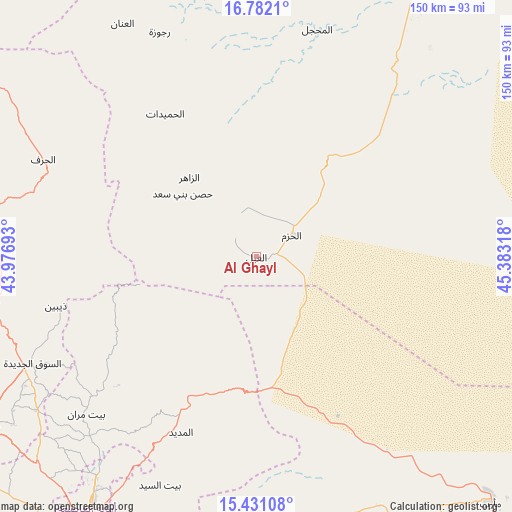
Al Ghayl GPS coordinates[2]
16° 6' 27.864" North, 44° 40' 48.18" East
| Map corner | latitude | longitude |
|---|---|---|
| Upper-left | 16.7821°, | 43.97693° |
| Center: | 16.10774°, | 44.68005° |
| Lower-right: | 15.43108°, | 45.38318° |
| Map W x H: | 150.2×150.2 km | = 93.3×93.3mi |
| max Lat: | 17.76999° ⇑15.6% North |
| Al Ghayl: | 16.10774° |
| min Lat: | ⇓84.4% South 12.18576° |
| min Long | Al Ghayl | max Long |
| 42.67107° | 44.68005° | 54.01895° |
| W 57.1%⇐ | ⇒42.9% E |
Elevation
Elevation of Al Ghayl is 1137 m = 3730 ft, and this is 167.8 m = 551 ft below average elevation for this country.
| Max E: |
2791 m = 9157 ft | 60.4% |
| Avg. | 1304.8 m = 4281 ft | |
| Al Ghayl | 1137 m = 3730 ft | |
Min E: |
4 m = 13 ft | 39.6% |
See also: Yemen elevation on elevation.city.
Geographical zone
Al Ghayl is located in North Torrid zone (between Equator and Tropic of Cancer). Distance of this Northern Tropic circle is 814.9 km =506.4 mi to North.| Distance of | km | miles | from Al Ghayl |
|---|---|---|---|
| North Pole | 8216 | 5105.2 | to North |
| Arctic Circle | 5610.2 | 3486 | to North |
| Tropic Cancer | 814.9 | 506.4 | to North |
| Equator | 1791 | 1112.9 | to South |


Nearby cities:
15 places around Al Ghayl: (largest is in red/bold)
• Al Khirāb
64.8 km =40.3 mi,  320°
320°
• Al Madīd
56 km =34.8 mi,  203°
203°
• Al Matūn
17 km =10.6 mi, 323°
• Al Maşlūb
10.1 km =6.3 mi,  325°
325°
• Al Ḩayfah
62.9 km =39.1 mi,  228°
228°
• Al Ḩazm
12.1 km =7.5 mi,  58°
58°
• Al Ḩumaydāt
49.7 km =30.9 mi, 327°
• Ar Rawḑ
14.8 km =9.2 mi,  110°
110°
• Asdās
57.3 km =35.6 mi,  131°
131°
• Az Zāhir
30.5 km =19 mi, 319°
• Bayt Marrān
68.6 km =42.6 mi, 227°
• Dhaybīn
60.6 km =37.7 mi,  256°
256°
• Madghil
68.5 km =42.6 mi,  145°
145°
• Majzar
30.4 km =18.9 mi,  160°
160°
• Ḩişn Banī Sa‘d
28.4 km =17.6 mi,  310°
310°
Sources, notices
• [Note1] Compared only with cities in Yemen existing in our database
• [Src1] Map data: © OpenStreetMap contributors (CC-BY-SA)
• [Src2] Other city data from geonames.org with taken over terms of usage.
• [Src3] Geographical zone / Annual Mean Temperature by Robert A. Rohde @ Wikipedia
