Al Ḩazm geodata
Al Ḩazm (Al Jawf) is a seat of a first-order administrative division; located in Yemen in Asia/Aden (GMT+3) time zone. With population of 18,241 people, there are 21 cities with bigger population in this country. Compared to other cities in Yemen, 86% of cities are located further ↓South; 59.7% of cities are located further ←West and 61% of cities have higher elevation than Al Ḩazm. Note1


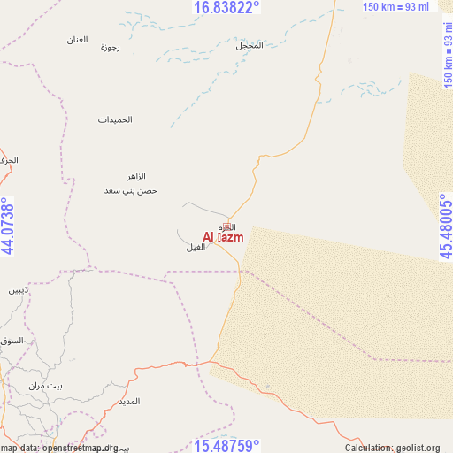
Al Ḩazm GPS coordinates[2]
16° 9' 50.616" North, 44° 46' 36.912" East
| Map corner | latitude | longitude |
|---|---|---|
| Upper-left | 16.83822°, | 44.0738° |
| Center: | 16.16406°, | 44.77692° |
| Lower-right: | 15.48759°, | 45.48005° |
| Map W x H: | 150.2×150.2 km | = 93.3×93.3mi |
| max Lat: | 17.76999° ⇑14% North |
| Al Ḩazm: | 16.16406° |
| min Lat: | ⇓86% South 12.18576° |
| min Long | Al Ḩazm | max Long |
| 42.67107° | 44.77692° | 54.01895° |
| W 59.7%⇐ | ⇒40.3% E |
Elevation
Elevation of Al Ḩazm is 1116 m = 3661 ft, and this is 188.8 m = 619 ft below average elevation for this country.
| Max E: |
2791 m = 9157 ft | 61% |
| Avg. | 1304.8 m = 4281 ft | |
| Al Ḩazm | 1116 m = 3661 ft | |
Min E: |
4 m = 13 ft | 39% |
See also: Yemen elevation on elevation.city.
Geographical zone
Al Ḩazm is located in North Torrid zone (between Equator and Tropic of Cancer). Distance of this Northern Tropic circle is 808.6 km =502.4 mi to North.| Distance of | km | miles | from Al Ḩazm |
|---|---|---|---|
| North Pole | 8209.8 | 5101.3 | to North |
| Arctic Circle | 5603.9 | 3482.1 | to North |
| Tropic Cancer | 808.6 | 502.4 | to North |
| Equator | 1797.3 | 1116.8 | to South |


Nearby cities:
15 places around Al Ḩazm: (largest is in red/bold)
• Al Ghayl
12.1 km =7.5 mi,  238°
238°
• Al Khirāb
67.7 km =42.1 mi,  309°
309°
• Al Madīd
66.3 km =41.2 mi,  209°
209°
• Al Matūn
21.8 km =13.5 mi,  289°
289°
• Al Maşlūb
16.2 km =10.1 mi,  277°
277°
• Al Maḩjal
61.4 km =38.2 mi,  7°
7°
• Al Ḩumaydāt
51.4 km =31.9 mi, 313°
• Ar Rawḑ
11.9 km =7.4 mi,  162°
162°
• Asdās
54.9 km =34.1 mi,  143°
143°
• Az Zāhir
34.6 km =21.5 mi,  299°
299°
• Dhaybīn
72.3 km =44.9 mi,  253°
253°
• Madghil
68.9 km =42.8 mi, 155°
• Majzar
34.9 km =21.7 mi,  180°
180°
• Rajūzah
71.1 km =44.2 mi,  327°
327°
• Ḩişn Banī Sa‘d
34.2 km =21.3 mi, 290°
Sources, notices
• [Note1] Compared only with cities in Yemen existing in our database
• [Src1] Map data: © OpenStreetMap contributors (CC-BY-SA)
• [Src2] Other city data from geonames.org with taken over terms of usage.
• [Src3] Geographical zone / Annual Mean Temperature by Robert A. Rohde @ Wikipedia
