Thaba Nchu geodata
Thaba Nchu (Orange Free State) is a populated place; located in South Africa in Africa/Johannesburg (GMT+2) time zone. With population of 38,616 people, there are 106 cities with bigger population in this country. Compared to other cities in South Africa, 58.1% of cities are located further ↑North; 60.8% of cities are located further →East and 83.5% of cities have lower elevation than Thaba Nchu. Note1
Administrative division(s):
- Level 1: Orange Free State
- Level 2: Mangaung Metropolitan Municipality
- Level 3: Mangaung


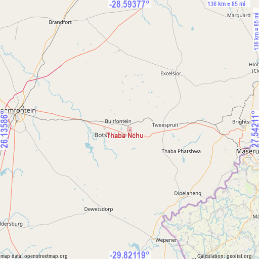
Thaba Nchu GPS coordinates[2]
29° 12' 33.552" South, 26° 50' 20.328" East
| Map corner | latitude | longitude |
|---|---|---|
| Upper-left | -28.59377°, | 26.13586° |
| Center: | -29.20932°, | 26.83898° |
| Lower-right: | -29.82119°, | 27.54211° |
| Map W x H: | 136.5×136.5 km | = 84.8×84.8mi |
| max Lat: | -22.34881° ⇑58.1% North |
| Thaba Nchu: | -29.20932° |
| min Lat: | ⇓41.9% South -34.66739° |
| min Long | Thaba Nchu | max Long |
| 16.8697° | 26.83898° | 32.26762° |
| W 39.2%⇐ | ⇒60.8% E |
Elevation
Elevation of Thaba Nchu is 1531 m = 5023 ft, and this is 561.4 m = 1842 ft above average elevation for this country.
| Max E: |
1873 m = 6145 ft | 16.5% |
| Thaba Nchu | 1531 m 5023 ft | |
| Avg. | 969.6 m = 3181 ft | |
Min E: |
7 m = 23 ft | 83.5% |
See also: South Africa elevation on elevation.city.
Geographical zone
Thaba Nchu is located in South temperate zone (between Tropic of Capricorn and the Antarctic Circle). Distance of this Southern Tropic circle is 641.9 km =398.9 mi to North.| Distance of | km | miles | from Thaba Nchu |
|---|---|---|---|
| Equator | 3247.8 | 2018.1 | to North |
| Tropic Capricorn | 641.9 | 398.9 | to North |
| Antarctic Circle | 4153.4 | 2580.8 | to South |
| South Pole | 6759.3 | 4200 | to South |


Nearby cities:
15 places around Thaba Nchu: (largest is in red/bold)
• Bloemfontein
61.5 km =38.2 mi,  279°
279°
• Botshabelo
12.7 km =7.9 mi,  239°
239°
• Brandfort
67.6 km =42 mi,  326°
326°
• Bultfontein
122.5 km =76.1 mi, 326°
• Clocolan
77.9 km =48.4 mi,  65°
65°
• Dewetsdorp
44.8 km =27.8 mi,  202°
202°
• Ficksburg
107.5 km =66.8 mi, 69°
• Ladybrand
60 km =37.3 mi,  88°
88°
• Marquard
83.6 km =51.9 mi,  43°
43°
• Senekal
124.9 km =77.6 mi, 37°
• Theunissen
89.8 km =55.8 mi,  351°
351°
• Ventersburg
128.3 km =79.7 mi,  13°
13°
• Virginia
122.9 km =76.4 mi,  1°
1°
• Winburg
78.6 km =48.8 mi, 12°
• Zastron
123.8 km =76.9 mi,  168°
168°
Sources, notices
• [Note1] Compared only with cities in South Africa existing in our database
• [Src1] Map data: © OpenStreetMap contributors (CC-BY-SA)
• [Src2] Other city data from geonames.org with taken over terms of usage.
• [Src3] Geographical zone / Annual Mean Temperature by Robert A. Rohde @ Wikipedia
