Bloemfontein geodata
Bloemfontein (Orange Free State) is a seat of a first-order administrative division; located in South Africa in Africa/Johannesburg (GMT+2) time zone. With population of 463,064 people, there are 11 cities with bigger population in this country. Compared to other cities in South Africa, 56.3% of cities are located further ↑North; 67.6% of cities are located further →East and 71.4% of cities have lower elevation than Bloemfontein. Note1
Administrative division(s):
- Level 1: Orange Free State
- Level 2: Mangaung Metropolitan Municipality
- Level 3: Mangaung


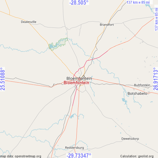
Bloemfontein GPS coordinates[2]
29° 7' 15.852" South, 26° 12' 50.4" East
| Map corner | latitude | longitude |
|---|---|---|
| Upper-left | -28.505°, | 25.51088° |
| Center: | -29.12107°, | 26.214° |
| Lower-right: | -29.73347°, | 26.91713° |
| Map W x H: | 136.6×136.6 km | = 84.9×84.9mi |
| max Lat: | -22.34881° ⇑56.3% North |
| Bloemfontein: | -29.12107° |
| min Lat: | ⇓43.7% South -34.66739° |
| min Long | Bloemfontein | max Long |
| 16.8697° | 26.214° | 32.26762° |
| W 32.4%⇐ | ⇒67.6% E |
Elevation
Elevation of Bloemfontein is 1396 m = 4580 ft, and this is 426.4 m = 1399 ft above average elevation for this country.
| Max E: |
1873 m = 6145 ft | 28.6% |
| Bloemfontein | 1396 m 4580 ft | |
| Avg. | 969.6 m = 3181 ft | |
Min E: |
7 m = 23 ft | 71.4% |
See also: Bloemfontein elevation on elevation.city.
Geographical zone
Bloemfontein is located in South temperate zone (between Tropic of Capricorn and the Antarctic Circle). Distance of this Southern Tropic circle is 632 km =392.7 mi to North.| Distance of | km | miles | from Bloemfontein |
|---|---|---|---|
| Equator | 3238 | 2012 | to North |
| Tropic Capricorn | 632 | 392.7 | to North |
| Antarctic Circle | 4163.2 | 2586.9 | to South |
| South Pole | 6769.1 | 4206.1 | to South |


Nearby cities:
15 places around Bloemfontein: (largest is in red/bold)
• Boshof
114.9 km =71.4 mi,  304°
304°
• Botshabelo
52.3 km =32.5 mi,  108°
108°
• Brandfort
52.6 km =32.7 mi,  27°
27°
• Bultfontein
92.9 km =57.7 mi,  356°
356°
• Clocolan
133.4 km =82.9 mi,  80°
80°
• Dewetsdorp
67.4 km =41.9 mi,  139°
139°
• Koffiefontein
121.7 km =75.6 mi,  254°
254°
• Ladybrand
121 km =75.2 mi,  93°
93°
• Marquard
128.8 km =80 mi,  66°
66°
• Thaba Nchu
61.5 km =38.2 mi,  99°
99°
• Theunissen
92.1 km =57.2 mi, 31°
• Trompsburg
109.8 km =68.2 mi,  202°
202°
• Virginia
129.8 km =80.7 mi, 29°
• Welkom
137 km =85.1 mi,  21°
21°
• Winburg
102.5 km =63.7 mi,  49°
49°
Sources, notices
• [Note1] Compared only with cities in South Africa existing in our database
• [Src1] Map data: © OpenStreetMap contributors (CC-BY-SA)
• [Src2] Other city data from geonames.org with taken over terms of usage.
• [Src3] Geographical zone / Annual Mean Temperature by Robert A. Rohde @ Wikipedia
