Botshabelo geodata
Botshabelo (Orange Free State) is a populated place; located in South Africa in Africa/Johannesburg (GMT+2) time zone. With population of 309,714 people, there are 18 cities with bigger population in this country. Compared to other cities in South Africa, 58.7% of cities are located further ↑North; 62.8% of cities are located further →East and 77.3% of cities have lower elevation than Botshabelo. Note1
Administrative division(s):
- Level 1: Orange Free State
- Level 2: Mangaung Metropolitan Municipality
- Level 3: Mangaung


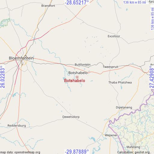
Botshabelo GPS coordinates[2]
29° 16' 2.532" South, 26° 43' 33.42" East
| Map corner | latitude | longitude |
|---|---|---|
| Upper-left | -28.65217°, | 26.02283° |
| Center: | -29.26737°, | 26.72595° |
| Lower-right: | -29.87889°, | 27.42908° |
| Map W x H: | 136.4×136.4 km | = 84.8×84.8mi |
| max Lat: | -22.34881° ⇑58.7% North |
| Botshabelo: | -29.26737° |
| min Lat: | ⇓41.3% South -34.66739° |
| min Long | Botshabelo | max Long |
| 16.8697° | 26.72595° | 32.26762° |
| W 37.2%⇐ | ⇒62.8% E |
Elevation
Elevation of Botshabelo is 1448 m = 4751 ft, and this is 478.4 m = 1570 ft above average elevation for this country.
| Max E: |
1873 m = 6145 ft | 22.7% |
| Botshabelo | 1448 m 4751 ft | |
| Avg. | 969.6 m = 3181 ft | |
Min E: |
7 m = 23 ft | 77.3% |
See also: Botshabelo elevation on elevation.city.
Geographical zone
Botshabelo is located in South temperate zone (between Tropic of Capricorn and the Antarctic Circle). Distance of this Southern Tropic circle is 648.3 km =402.8 mi to North.| Distance of | km | miles | from Botshabelo |
|---|---|---|---|
| Equator | 3254.2 | 2022.1 | to North |
| Tropic Capricorn | 648.3 | 402.8 | to North |
| Antarctic Circle | 4146.9 | 2576.8 | to South |
| South Pole | 6752.8 | 4196 | to South |


Nearby cities:
15 places around Botshabelo: (largest is in red/bold)
• Bloemfontein
52.3 km =32.5 mi,  288°
288°
• Brandfort
68.2 km =42.4 mi,  337°
337°
• Bultfontein
122.6 km =76.2 mi,  332°
332°
• Clocolan
90.6 km =56.3 mi,  64°
64°
• Dewetsdorp
35.6 km =22.1 mi,  189°
189°
• Ficksburg
120 km =74.6 mi,  68°
68°
• Ladybrand
71.4 km =44.4 mi,  83°
83°
• Marquard
95.9 km =59.6 mi,  45°
45°
• Senekal
136.8 km =85 mi,  39°
39°
• Thaba Nchu
12.7 km =7.9 mi, 59°
• Theunissen
95.3 km =59.2 mi,  358°
358°
• Trompsburg
124.9 km =77.6 mi,  227°
227°
• Virginia
130.1 km =80.8 mi,  6°
6°
• Winburg
87.8 km =54.6 mi,  18°
18°
• Zastron
120.1 km =74.6 mi,  163°
163°
Sources, notices
• [Note1] Compared only with cities in South Africa existing in our database
• [Src1] Map data: © OpenStreetMap contributors (CC-BY-SA)
• [Src2] Other city data from geonames.org with taken over terms of usage.
• [Src3] Geographical zone / Annual Mean Temperature by Robert A. Rohde @ Wikipedia
