Brandfort geodata
Brandfort (Orange Free State) is a populated place; located in South Africa in Africa/Johannesburg (GMT+2) time zone. With population of 12,091 people, there are 194 cities with bigger population in this country. Compared to other cities in South Africa, 51.6% of cities are located further ↑North; 65.8% of cities are located further →East and 72.9% of cities have lower elevation than Brandfort. Note1
Administrative division(s):
- Level 1: Orange Free State
- Level 2: Lejweleputswa District Municipality
- Level 3: Masilonyana


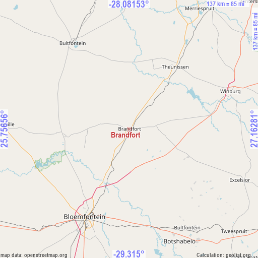
Brandfort GPS coordinates[2]
28° 42' 0.288" South, 26° 27' 34.848" East
| Map corner | latitude | longitude |
|---|---|---|
| Upper-left | -28.08153°, | 25.75656° |
| Center: | -28.70008°, | 26.45968° |
| Lower-right: | -29.315°, | 27.16281° |
| Map W x H: | 137.1×137.1 km | = 85.2×85.2mi |
| max Lat: | -22.34881° ⇑51.6% North |
| Brandfort: | -28.70008° |
| min Lat: | ⇓48.4% South -34.66739° |
| min Long | Brandfort | max Long |
| 16.8697° | 26.45968° | 32.26762° |
| W 34.2%⇐ | ⇒65.8% E |
Elevation
Elevation of Brandfort is 1403 m = 4603 ft, and this is 433.4 m = 1422 ft above average elevation for this country.
| Max E: |
1873 m = 6145 ft | 27.1% |
| Brandfort | 1403 m 4603 ft | |
| Avg. | 969.6 m = 3181 ft | |
Min E: |
7 m = 23 ft | 72.9% |
See also: South Africa elevation on elevation.city.
Geographical zone
Brandfort is located in South temperate zone (between Tropic of Capricorn and the Antarctic Circle). Distance of this Southern Tropic circle is 585.2 km =363.6 mi to North.| Distance of | km | miles | from Brandfort |
|---|---|---|---|
| Equator | 3191.1 | 1982.9 | to North |
| Tropic Capricorn | 585.2 | 363.6 | to North |
| Antarctic Circle | 4210 | 2616 | to South |
| South Pole | 6815.9 | 4235.2 | to South |


Nearby cities:
15 places around Brandfort: (largest is in red/bold)
• Allanridge
106.7 km =66.3 mi,  9°
9°
• Bloemfontein
52.6 km =32.7 mi,  207°
207°
• Botshabelo
68.2 km =42.4 mi,  157°
157°
• Bultfontein
55 km =34.2 mi,  326°
326°
• Dewetsdorp
100.1 km =62.2 mi,  168°
168°
• Hennenman
97.6 km =60.6 mi,  34°
34°
• Kutloanong
100.5 km =62.4 mi,  16°
16°
• Marquard
94.8 km =58.9 mi,  87°
87°
• Thaba Nchu
67.6 km =42 mi,  146°
146°
• Theunissen
39.9 km =24.8 mi,  36°
36°
• Ventersburg
95.2 km =59.2 mi, 44°
• Virginia
77.3 km =48 mi, 30°
• Welkom
84.8 km =52.7 mi, 18°
• Wesselsbron
94.4 km =58.7 mi,  354°
354°
• Winburg
57.3 km =35.6 mi,  69°
69°
Sources, notices
• [Note1] Compared only with cities in South Africa existing in our database
• [Src1] Map data: © OpenStreetMap contributors (CC-BY-SA)
• [Src2] Other city data from geonames.org with taken over terms of usage.
• [Src3] Geographical zone / Annual Mean Temperature by Robert A. Rohde @ Wikipedia
