Bultfontein geodata
Bultfontein (Orange Free State) is a seat of a third-order administrative division; located in South Africa in Africa/Johannesburg (GMT+2) time zone. In our database, there are 257 cities with bigger population. Compared to other cities in South Africa, 53.4% of cities are located further ↓South; 68.1% of cities are located further →East and 66.1% of cities have lower elevation than Bultfontein. Note1
Administrative division(s):
- Level 1: Orange Free State
- Level 2: Lejweleputswa District Municipality
- Level 3: Tswelopele


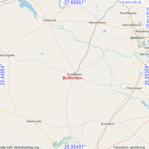
Bultfontein GPS coordinates[2]
28° 17' 15.216" South, 26° 8' 59.856" East
| Map corner | latitude | longitude |
|---|---|---|
| Upper-left | -27.66661°, | 25.44684° |
| Center: | -28.28756°, | 26.14996° |
| Lower-right: | -28.90491°, | 26.85309° |
| Map W x H: | 137.7×137.7 km | = 85.6×85.6mi |
| max Lat: | -22.34881° ⇑46.6% North |
| Bultfontein: | -28.28756° |
| min Lat: | ⇓53.4% South -34.66739° |
| min Long | Bultfontein | max Long |
| 16.8697° | 26.14996° | 32.26762° |
| W 31.9%⇐ | ⇒68.1% E |
Elevation
Elevation of Bultfontein is 1319 m = 4327 ft, and this is 349.4 m = 1146 ft above average elevation for this country.
| Max E: |
1873 m = 6145 ft | 33.9% |
| Bultfontein | 1319 m 4327 ft | |
| Avg. | 969.6 m = 3181 ft | |
Min E: |
7 m = 23 ft | 66.1% |
See also: South Africa elevation on elevation.city.
Geographical zone
Bultfontein is located in South temperate zone (between Tropic of Capricorn and the Antarctic Circle). Distance of this Southern Tropic circle is 539.4 km =335.2 mi to North.| Distance of | km | miles | from Bultfontein |
|---|---|---|---|
| Equator | 3145.3 | 1954.4 | to North |
| Tropic Capricorn | 539.4 | 335.2 | to North |
| Antarctic Circle | 4255.9 | 2644.5 | to South |
| South Pole | 6861.8 | 4263.7 | to South |


Nearby cities:
15 places around Bultfontein: (largest is in red/bold)
• Allanridge
76.6 km =47.6 mi,  39°
39°
• Bloemfontein
92.9 km =57.7 mi,  176°
176°
• Bloemhof
89 km =55.3 mi,  323°
323°
• Boshof
93.3 km =58 mi,  252°
252°
• Brandfort
55 km =34.2 mi,  146°
146°
• Christiana
105.5 km =65.6 mi,  293°
293°
• Hennenman
92.4 km =57.4 mi,  68°
68°
• Hoopstad
55.9 km =34.7 mi,  334°
334°
• Kutloanong
77.6 km =48.2 mi,  49°
49°
• Theunissen
55.6 km =34.5 mi,  104°
104°
• Ventersburg
99.4 km =61.8 mi,  76°
76°
• Virginia
73.1 km =45.4 mi, 73°
• Welkom
66.9 km =41.6 mi,  58°
58°
• Wesselsbron
52.6 km =32.7 mi,  23°
23°
• Winburg
87.9 km =54.6 mi,  106°
106°
Sources, notices
• [Note1] Compared only with cities in South Africa existing in our database
• [Src1] Map data: © OpenStreetMap contributors (CC-BY-SA)
• [Src2] Other city data from geonames.org with taken over terms of usage.
• [Src3] Geographical zone / Annual Mean Temperature by Robert A. Rohde @ Wikipedia
