Senekal geodata
Senekal (Orange Free State) is a populated place; located in South Africa in Africa/Johannesburg (GMT+2) time zone. With population of 39,584 people, there are 105 cities with bigger population in this country. Compared to other cities in South Africa, 53.1% of cities are located further ↓South; 50.7% of cities are located further →East and 75.5% of cities have lower elevation than Senekal. Note1
Administrative division(s):
- Level 1: Orange Free State
- Level 2: Thabo Mofutsanyana District Municipality
- Level 3: Setsoto


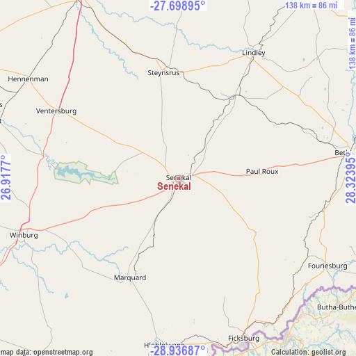
Senekal GPS coordinates[2]
28° 19' 10.956" South, 27° 37' 14.952" East
| Map corner | latitude | longitude |
|---|---|---|
| Upper-left | -27.69895°, | 26.9177° |
| Center: | -28.31971°, | 27.62082° |
| Lower-right: | -28.93687°, | 28.32395° |
| Map W x H: | 137.6×137.6 km | = 85.5×85.5mi |
| max Lat: | -22.34881° ⇑46.9% North |
| Senekal: | -28.31971° |
| min Lat: | ⇓53.1% South -34.66739° |
| min Long | Senekal | max Long |
| 16.8697° | 27.62082° | 32.26762° |
| W 49.3%⇐ | ⇒50.7% E |
Elevation
Elevation of Senekal is 1431 m = 4695 ft, and this is 461.4 m = 1514 ft above average elevation for this country.
| Max E: |
1873 m = 6145 ft | 24.5% |
| Senekal | 1431 m 4695 ft | |
| Avg. | 969.6 m = 3181 ft | |
Min E: |
7 m = 23 ft | 75.5% |
See also: South Africa elevation on elevation.city.
Geographical zone
Senekal is located in South temperate zone (between Tropic of Capricorn and the Antarctic Circle). Distance of this Southern Tropic circle is 542.9 km =337.3 mi to North.| Distance of | km | miles | from Senekal |
|---|---|---|---|
| Equator | 3148.9 | 1956.6 | to North |
| Tropic Capricorn | 542.9 | 337.3 | to North |
| Antarctic Circle | 4252.3 | 2642.3 | to South |
| South Pole | 6858.2 | 4261.5 | to South |


Nearby cities:
15 places around Senekal: (largest is in red/bold)
• Bethlehem
67.9 km =42.2 mi,  81°
81°
• Clocolan
66.3 km =41.2 mi,  184°
184°
• Ficksburg
66.2 km =41.1 mi,  157°
157°
• Hennenman
69.8 km =43.4 mi,  303°
303°
• Kroonstad
83.5 km =51.9 mi,  333°
333°
• Kutloanong
101.1 km =62.8 mi, 302°
• Ladybrand
98.6 km =61.3 mi,  189°
189°
• Lindley
56.8 km =35.3 mi,  30°
30°
• Marquard
42.6 km =26.5 mi,  205°
205°
• Reitz
97.9 km =60.8 mi,  53°
53°
• Theunissen
90.6 km =56.3 mi,  263°
263°
• Ventersburg
54 km =33.6 mi, 298°
• Virginia
77.8 km =48.3 mi,  287°
287°
• Welkom
94.8 km =58.9 mi, 293°
• Winburg
63.7 km =39.6 mi,  249°
249°
Sources, notices
• [Note1] Compared only with cities in South Africa existing in our database
• [Src1] Map data: © OpenStreetMap contributors (CC-BY-SA)
• [Src2] Other city data from geonames.org with taken over terms of usage.
• [Src3] Geographical zone / Annual Mean Temperature by Robert A. Rohde @ Wikipedia
