Kutloanong geodata
Kutloanong (Orange Free State) is a populated place; located in South Africa in Africa/Johannesburg (GMT+2) time zone. With population of 95,008 people, there are 55 cities with bigger population in this country. Compared to other cities in South Africa, 59.3% of cities are located further ↓South; 62.2% of cities are located further →East and 67.3% of cities have lower elevation than Kutloanong. Note1
Administrative division(s):
- Level 1: Orange Free State
- Level 2: Lejweleputswa District Municipality
- Level 3: Matjhabeng


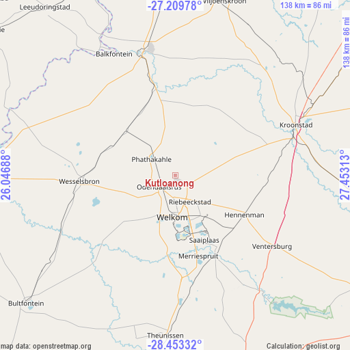
Kutloanong GPS coordinates[2]
27° 49' 59.988" South, 26° 45' 0" East
| Map corner | latitude | longitude |
|---|---|---|
| Upper-left | -27.20978°, | 26.04688° |
| Center: | -27.83333°, | 26.75° |
| Lower-right: | -28.45332°, | 27.45313° |
| Map W x H: | 138.3×138.3 km | = 85.9×85.9mi |
| max Lat: | -22.34881° ⇑40.7% North |
| Kutloanong: | -27.83333° |
| min Lat: | ⇓59.3% South -34.66739° |
| min Long | Kutloanong | max Long |
| 16.8697° | 26.75° | 32.26762° |
| W 37.8%⇐ | ⇒62.2% E |
Elevation
Elevation of Kutloanong is 1326 m = 4350 ft, and this is 356.4 m = 1169 ft above average elevation for this country.
| Max E: |
1873 m = 6145 ft | 32.7% |
| Kutloanong | 1326 m 4350 ft | |
| Avg. | 969.6 m = 3181 ft | |
Min E: |
7 m = 23 ft | 67.3% |
See also: Kutloanong elevation on elevation.city.
Geographical zone
Kutloanong is located in South temperate zone (between Tropic of Capricorn and the Antarctic Circle). Distance of this Southern Tropic circle is 488.9 km =303.8 mi to North.| Distance of | km | miles | from Kutloanong |
|---|---|---|---|
| Equator | 3094.8 | 1923 | to North |
| Tropic Capricorn | 488.9 | 303.8 | to North |
| Antarctic Circle | 4306.4 | 2675.9 | to South |
| South Pole | 6912.3 | 4295.1 | to South |


Nearby cities:
15 places around Kutloanong: (largest is in red/bold)
• Allanridge
13.6 km =8.5 mi,  310°
310°
• Bothaville
51.1 km =31.8 mi,  345°
345°
• Brandfort
100.5 km =62.4 mi,  196°
196°
• Bultfontein
77.6 km =48.2 mi,  229°
229°
• Hennenman
31.3 km =19.4 mi,  120°
120°
• Hoopstad
82.8 km =51.4 mi,  270°
270°
• Kroonstad
51.9 km =32.2 mi,  66°
66°
• Orkney
95.2 km =59.2 mi,  355°
355°
• Theunissen
64.4 km =40 mi,  184°
184°
• Ventersburg
47.3 km =29.4 mi,  126°
126°
• Viljoenskroon
72.2 km =44.9 mi,  15°
15°
• Virginia
32.2 km =20 mi,  159°
159°
• Welkom
16.1 km =10 mi,  185°
185°
• Wesselsbron
37.8 km =23.5 mi, 266°
• Winburg
80.3 km =49.9 mi, 161°
Sources, notices
• [Note1] Compared only with cities in South Africa existing in our database
• [Src1] Map data: © OpenStreetMap contributors (CC-BY-SA)
• [Src2] Other city data from geonames.org with taken over terms of usage.
• [Src3] Geographical zone / Annual Mean Temperature by Robert A. Rohde @ Wikipedia
