Lindley geodata
Lindley (Orange Free State) is a populated place; located in South Africa in Africa/Johannesburg (GMT+2) time zone. With population of 12,000 people, there are 196 cities with bigger population in this country. Compared to other cities in South Africa, 58.7% of cities are located further ↓South; 54.3% of cities are located further ←West and 82.3% of cities have lower elevation than Lindley. Note1
Administrative division(s):
- Level 1: Orange Free State
- Level 2: Thabo Mofutsanyana District Municipality
- Level 3: Nketoana


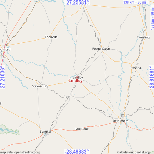
Lindley GPS coordinates[2]
27° 52' 44.76" South, 27° 54' 48.528" East
| Map corner | latitude | longitude |
|---|---|---|
| Upper-left | -27.25581°, | 27.21036° |
| Center: | -27.8791°, | 27.91348° |
| Lower-right: | -28.49883°, | 28.61661° |
| Map W x H: | 138.2×138.2 km | = 85.9×85.9mi |
| max Lat: | -22.34881° ⇑41.3% North |
| Lindley: | -27.8791° |
| min Lat: | ⇓58.7% South -34.66739° |
| min Long | Lindley | max Long |
| 16.8697° | 27.91348° | 32.26762° |
| W 54.3%⇐ | ⇒45.7% E |
Elevation
Elevation of Lindley is 1519 m = 4984 ft, and this is 549.4 m = 1802 ft above average elevation for this country.
| Max E: |
1873 m = 6145 ft | 17.7% |
| Lindley | 1519 m 4984 ft | |
| Avg. | 969.6 m = 3181 ft | |
Min E: |
7 m = 23 ft | 82.3% |
See also: South Africa elevation on elevation.city.
Geographical zone
Lindley is located in South temperate zone (between Tropic of Capricorn and the Antarctic Circle). Distance of this Southern Tropic circle is 493.9 km =306.9 mi to North.| Distance of | km | miles | from Lindley |
|---|---|---|---|
| Equator | 3099.9 | 1926.2 | to North |
| Tropic Capricorn | 493.9 | 306.9 | to North |
| Antarctic Circle | 4301.3 | 2672.7 | to South |
| South Pole | 6907.2 | 4291.9 | to South |


Nearby cities:
15 places around Lindley: (largest is in red/bold)
• Bethlehem
55 km =34.2 mi,  135°
135°
• Deneysville
111.4 km =69.2 mi,  9°
9°
• Ficksburg
110.5 km =68.7 mi,  181°
181°
• Frankfort
88.1 km =54.7 mi,  40°
40°
• Heilbron
66.7 km =41.4 mi,  4°
4°
• Hennenman
88 km =54.7 mi,  262°
262°
• Koppies
78.4 km =48.7 mi,  334°
334°
• Kroonstad
71.4 km =44.4 mi,  290°
290°
• Marquard
99.3 km =61.7 mi,  208°
208°
• Reitz
51.2 km =31.8 mi,  80°
80°
• Senekal
56.8 km =35.3 mi, 210°
• Ventersburg
79.5 km =49.4 mi,  253°
253°
• Virginia
105.8 km =65.7 mi, 256°
• Vredefort
111 km =69 mi, 330°
• Winburg
113.6 km =70.6 mi,  231°
231°
Sources, notices
• [Note1] Compared only with cities in South Africa existing in our database
• [Src1] Map data: © OpenStreetMap contributors (CC-BY-SA)
• [Src2] Other city data from geonames.org with taken over terms of usage.
• [Src3] Geographical zone / Annual Mean Temperature by Robert A. Rohde @ Wikipedia
