Welkom geodata
Welkom (Orange Free State) is a seat of a second-order administrative division; located in South Africa in Africa/Johannesburg (GMT+2) time zone. With population of 431,944 people, there are 13 cities with bigger population in this country. Compared to other cities in South Africa, 57.2% of cities are located further ↓South; 62.5% of cities are located further →East and 70.8% of cities have lower elevation than Welkom. Note1
Administrative division(s):
- Level 1: Orange Free State
- Level 2: Lejweleputswa District Municipality
- Level 3: Matjhabeng


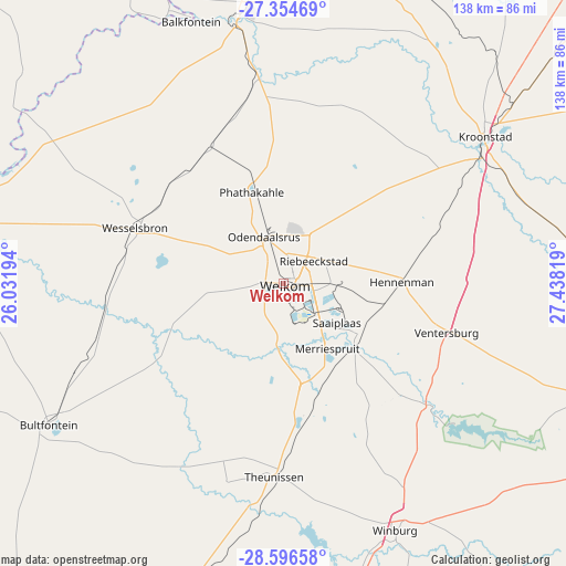
Welkom GPS coordinates[2]
27° 58' 38.712" South, 26° 44' 6.216" East
| Map corner | latitude | longitude |
|---|---|---|
| Upper-left | -27.35469°, | 26.03194° |
| Center: | -27.97742°, | 26.73506° |
| Lower-right: | -28.59658°, | 27.43819° |
| Map W x H: | 138.1×138.1 km | = 85.8×85.8mi |
| max Lat: | -22.34881° ⇑42.8% North |
| Welkom: | -27.97742° |
| min Lat: | ⇓57.2% South -34.66739° |
| min Long | Welkom | max Long |
| 16.8697° | 26.73506° | 32.26762° |
| W 37.5%⇐ | ⇒62.5% E |
Elevation
Elevation of Welkom is 1376 m = 4514 ft, and this is 406.4 m = 1333 ft above average elevation for this country.
| Max E: |
1873 m = 6145 ft | 29.2% |
| Welkom | 1376 m 4514 ft | |
| Avg. | 969.6 m = 3181 ft | |
Min E: |
7 m = 23 ft | 70.8% |
See also: Welkom elevation on elevation.city.
Geographical zone
Welkom is located in South temperate zone (between Tropic of Capricorn and the Antarctic Circle). Distance of this Southern Tropic circle is 504.9 km =313.7 mi to North.| Distance of | km | miles | from Welkom |
|---|---|---|---|
| Equator | 3110.8 | 1933 | to North |
| Tropic Capricorn | 504.9 | 313.7 | to North |
| Antarctic Circle | 4290.4 | 2665.9 | to South |
| South Pole | 6896.3 | 4285.2 | to South |


Nearby cities:
15 places around Welkom: (largest is in red/bold)
• Allanridge
26.4 km =16.4 mi,  340°
340°
• Bothaville
66.5 km =41.3 mi,  349°
349°
• Brandfort
84.8 km =52.7 mi,  198°
198°
• Bultfontein
66.9 km =41.6 mi,  238°
238°
• Hennenman
28.4 km =17.6 mi,  89°
89°
• Hoopstad
82.8 km =51.4 mi,  281°
281°
• Kroonstad
61.1 km =38 mi,  53°
53°
• Kutloanong
16.1 km =10 mi,  5°
5°
• Senekal
94.8 km =58.9 mi,  113°
113°
• Theunissen
48.3 km =30 mi,  183°
183°
• Ventersburg
41.3 km =25.7 mi, 106°
• Viljoenskroon
88.1 km =54.7 mi, 13°
• Virginia
19 km =11.8 mi,  137°
137°
• Wesselsbron
38.8 km =24.1 mi,  290°
290°
• Winburg
65.8 km =40.9 mi,  155°
155°
Sources, notices
• [Note1] Compared only with cities in South Africa existing in our database
• [Src1] Map data: © OpenStreetMap contributors (CC-BY-SA)
• [Src2] Other city data from geonames.org with taken over terms of usage.
• [Src3] Geographical zone / Annual Mean Temperature by Robert A. Rohde @ Wikipedia
