Hennenman geodata
Hennenman (Orange Free State) is a populated place; located in South Africa in Africa/Johannesburg (GMT+2) time zone. With population of 22,847 people, there are 139 cities with bigger population in this country. Compared to other cities in South Africa, 57.5% of cities are located further ↓South; 58.4% of cities are located further →East and 71.4% of cities have lower elevation than Hennenman. Note1
Administrative division(s):
- Level 1: Orange Free State
- Level 2: Lejweleputswa District Municipality
- Level 3: Matjhabeng


Hennenman GPS coordinates[2]
27° 58' 35.544" South, 27° 1' 27.228" East
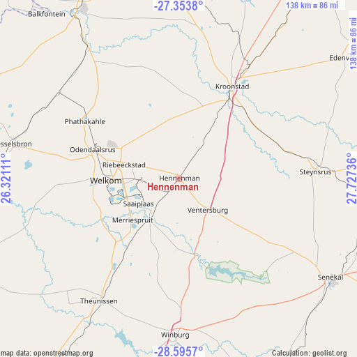
| Map corner | latitude | longitude |
|---|---|---|
| Upper-left | -27.3538°, | 26.32111° |
| Center: | -27.97654°, | 27.02423° |
| Lower-right: | -28.5957°, | 27.72736° |
| Map W x H: | 138.1×138.1 km | = 85.8×85.8mi |
| max Lat: | -22.34881° ⇑42.5% North |
| Hennenman: | -27.97654° |
| min Lat: | ⇓57.5% South -34.66739° |
| min Long | Hennenman | max Long |
| 16.8697° | 27.02423° | 32.26762° |
| W 41.6%⇐ | ⇒58.4% E |
Elevation
Elevation of Hennenman is 1396 m = 4580 ft, and this is 426.4 m = 1399 ft above average elevation for this country.
| Max E: |
1873 m = 6145 ft | 28.6% |
| Hennenman | 1396 m 4580 ft | |
| Avg. | 969.6 m = 3181 ft | |
Min E: |
7 m = 23 ft | 71.4% |
See also: South Africa elevation on elevation.city.
Geographical zone
Hennenman is located in South temperate zone (between Tropic of Capricorn and the Antarctic Circle). Distance of this Southern Tropic circle is 504.8 km =313.7 mi to North.| Distance of | km | miles | from Hennenman |
|---|---|---|---|
| Equator | 3110.7 | 1932.9 | to North |
| Tropic Capricorn | 504.8 | 313.7 | to North |
| Antarctic Circle | 4290.5 | 2666 | to South |
| South Pole | 6896.4 | 4285.2 | to South |


Nearby cities:
15 places around Hennenman: (largest is in red/bold)
• Allanridge
44.8 km =27.8 mi,  303°
303°
• Bothaville
76.7 km =47.7 mi,  328°
328°
• Bultfontein
92.4 km =57.4 mi,  248°
248°
• Kroonstad
41.8 km =26 mi,  29°
29°
• Kutloanong
31.3 km =19.4 mi, 300°
• Lindley
88 km =54.7 mi,  82°
82°
• Marquard
86.2 km =53.6 mi,  152°
152°
• Senekal
69.8 km =43.4 mi,  123°
123°
• Theunissen
57.8 km =35.9 mi,  213°
213°
• Ventersburg
16.5 km =10.3 mi,  137°
137°
• Viljoenskroon
85.7 km =53.3 mi,  355°
355°
• Virginia
21 km =13 mi,  227°
227°
• Welkom
28.4 km =17.6 mi,  269°
269°
• Wesselsbron
66.1 km =41.1 mi,  281°
281°
• Winburg
60.2 km =37.4 mi,  181°
181°
Sources, notices
• [Note1] Compared only with cities in South Africa existing in our database
• [Src1] Map data: © OpenStreetMap contributors (CC-BY-SA)
• [Src2] Other city data from geonames.org with taken over terms of usage.
• [Src3] Geographical zone / Annual Mean Temperature by Robert A. Rohde @ Wikipedia
