Reitz geodata
Reitz (Orange Free State) is a seat of a third-order administrative division; located in South Africa in Africa/Johannesburg (GMT+2) time zone. With population of 16,637 people, there are 160 cities with bigger population in this country. Compared to other cities in South Africa, 59.9% of cities are located further ↓South; 64.6% of cities are located further ←West and 94.1% of cities have lower elevation than Reitz. Note1
Administrative division(s):
- Level 1: Orange Free State
- Level 2: Thabo Mofutsanyana District Municipality
- Level 3: Nketoana


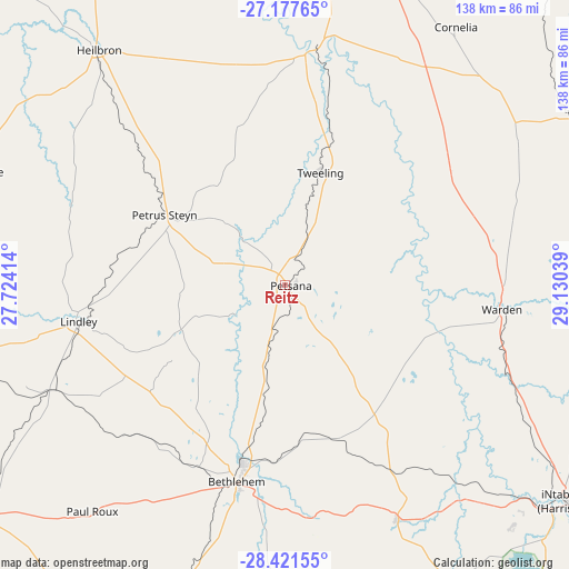
Reitz GPS coordinates[2]
27° 48' 4.968" South, 28° 25' 38.136" East
| Map corner | latitude | longitude |
|---|---|---|
| Upper-left | -27.17765°, | 27.72414° |
| Center: | -27.80138°, | 28.42726° |
| Lower-right: | -28.42155°, | 29.13039° |
| Map W x H: | 138.3×138.3 km | = 85.9×85.9mi |
| max Lat: | -22.34881° ⇑40.1% North |
| Reitz: | -27.80138° |
| min Lat: | ⇓59.9% South -34.66739° |
| min Long | Reitz | max Long |
| 16.8697° | 28.42726° | 32.26762° |
| W 64.6%⇐ | ⇒35.4% E |
Elevation
Elevation of Reitz is 1643 m = 5390 ft, and this is 673.4 m = 2209 ft above average elevation for this country.
| Max E: |
1873 m = 6145 ft | 5.9% |
| Reitz | 1643 m 5390 ft | |
| Avg. | 969.6 m = 3181 ft | |
Min E: |
7 m = 23 ft | 94.1% |
See also: South Africa elevation on elevation.city.
Geographical zone
Reitz is located in South temperate zone (between Tropic of Capricorn and the Antarctic Circle). Distance of this Southern Tropic circle is 485.3 km =301.6 mi to North.| Distance of | km | miles | from Reitz |
|---|---|---|---|
| Equator | 3091.2 | 1920.8 | to North |
| Tropic Capricorn | 485.3 | 301.6 | to North |
| Antarctic Circle | 4310 | 2678.1 | to South |
| South Pole | 6915.8 | 4297.3 | to South |


Nearby cities:
15 places around Reitz: (largest is in red/bold)
• Balfour
127.6 km =79.3 mi,  7°
7°
• Bethlehem
49.2 km =30.6 mi,  193°
193°
• Deneysville
106.4 km =66.1 mi,  342°
342°
• Frankfort
58.5 km =36.4 mi, 6°
• Harrismith
86.6 km =53.8 mi,  127°
127°
• Heilbron
73.3 km =45.5 mi,  322°
322°
• Koppies
104.6 km =65 mi,  306°
306°
• Kroonstad
118.6 km =73.7 mi,  278°
278°
• Lindley
51.2 km =31.8 mi,  260°
260°
• Phuthaditjhaba
88.9 km =55.2 mi,  154°
154°
• Sasolburg
125.3 km =77.9 mi,  331°
331°
• Senekal
97.9 km =60.8 mi,  233°
233°
• Standerton
125.6 km =78 mi,  39°
39°
• Villiers
87.4 km =54.3 mi, 11°
• Vrede
83.9 km =52.1 mi,  60°
60°
Sources, notices
• [Note1] Compared only with cities in South Africa existing in our database
• [Src1] Map data: © OpenStreetMap contributors (CC-BY-SA)
• [Src2] Other city data from geonames.org with taken over terms of usage.
• [Src3] Geographical zone / Annual Mean Temperature by Robert A. Rohde @ Wikipedia
