Vredefort geodata
Vredefort (Orange Free State) is a populated place; located in South Africa in Africa/Johannesburg (GMT+2) time zone. With population of 10,649 people, there are 209 cities with bigger population in this country. Compared to other cities in South Africa, 67.8% of cities are located further ↓South; 54.6% of cities are located further →East and 75.2% of cities have lower elevation than Vredefort. Note1
Administrative division(s):
- Level 1: Orange Free State
- Level 2: Fezile Dabi District Municipality
- Level 3: Ngwathe


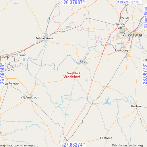
Vredefort GPS coordinates[2]
27° 0' 28.98" South, 27° 21' 52.56" East
| Map corner | latitude | longitude |
|---|---|---|
| Upper-left | -26.37987°, | 26.66148° |
| Center: | -27.00805°, | 27.3646° |
| Lower-right: | -27.63274°, | 28.06773° |
| Map W x H: | 139.3×139.3 km | = 86.6×86.6mi |
| max Lat: | -22.34881° ⇑32.2% North |
| Vredefort: | -27.00805° |
| min Lat: | ⇓67.8% South -34.66739° |
| min Long | Vredefort | max Long |
| 16.8697° | 27.3646° | 32.26762° |
| W 45.4%⇐ | ⇒54.6% E |
Elevation
Elevation of Vredefort is 1425 m = 4675 ft, and this is 455.4 m = 1494 ft above average elevation for this country.
| Max E: |
1873 m = 6145 ft | 24.8% |
| Vredefort | 1425 m 4675 ft | |
| Avg. | 969.6 m = 3181 ft | |
Min E: |
7 m = 23 ft | 75.2% |
See also: South Africa elevation on elevation.city.
Geographical zone
Vredefort is located in South temperate zone (between Tropic of Capricorn and the Antarctic Circle). Distance of this Southern Tropic circle is 397.1 km =246.7 mi to North.| Distance of | km | miles | from Vredefort |
|---|---|---|---|
| Equator | 3003 | 1866 | to North |
| Tropic Capricorn | 397.1 | 246.7 | to North |
| Antarctic Circle | 4398.2 | 2732.9 | to South |
| South Pole | 7004 | 4352.1 | to South |


Nearby cities:
15 places around Vredefort: (largest is in red/bold)
• Carletonville
72 km =44.7 mi,  2°
2°
• Deneysville
73.8 km =45.9 mi,  79°
79°
• Fochville
59.2 km =36.8 mi,  12°
12°
• Heilbron
67.2 km =41.8 mi,  116°
116°
• Klerksdorp
71.3 km =44.3 mi,  284°
284°
• Koppies
33.3 km =20.7 mi,  141°
141°
• Kroonstad
72.6 km =45.1 mi,  190°
190°
• Orkney
68.6 km =42.6 mi,  272°
272°
• Parys
14.8 km =9.2 mi,  38°
38°
• Potchefstroom
41.7 km =25.9 mi,  320°
320°
• Sasolburg
49.8 km =30.9 mi,  64°
64°
• Stilfontein
61.8 km =38.4 mi,  287°
287°
• Vanderbijlpark
57.4 km =35.7 mi,  54°
54°
• Vereeniging
67 km =41.6 mi, 56°
• Viljoenskroon
46.8 km =29.1 mi,  241°
241°
Sources, notices
• [Note1] Compared only with cities in South Africa existing in our database
• [Src1] Map data: © OpenStreetMap contributors (CC-BY-SA)
• [Src2] Other city data from geonames.org with taken over terms of usage.
• [Src3] Geographical zone / Annual Mean Temperature by Robert A. Rohde @ Wikipedia
