Bhisho geodata
Bhisho (Eastern Cape) is a seat of a first-order administrative division; located in South Africa in Africa/Johannesburg (GMT+2) time zone. With population of 137,287 people, there are 39 cities with bigger population in this country. Compared to other cities in South Africa, 83.5% of cities are located further ↑North; 53.1% of cities are located further →East and 74.6% of cities have higher elevation than Bhisho. Note1
Administrative division(s):
- Level 1: Eastern Cape
- Level 2: Buffalo City Metropolitan Municipality
- Level 3: Buffalo City


Bhisho GPS coordinates[2]
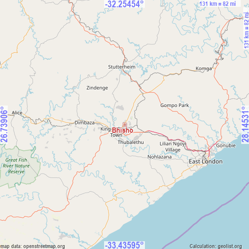
32° 50' 49.956" South, 27° 26' 31.848" East
| Map corner | latitude | longitude |
|---|---|---|
| Upper-left | -32.25454°, | 26.73906° |
| Center: | -32.84721°, | 27.44218° |
| Lower-right: | -33.43595°, | 28.14531° |
| Map W x H: | 131.4×131.4 km | = 81.6×81.6mi |
| max Lat: | -22.34881° ⇑83.5% North |
| Bhisho: | -32.84721° |
| min Lat: | ⇓16.5% South -34.66739° |
| min Long | Bhisho | max Long |
| 16.8697° | 27.44218° | 32.26762° |
| W 46.9%⇐ | ⇒53.1% E |
Elevation
Elevation of Bhisho is 535 m = 1755 ft, and this is 434.6 m = 1426 ft below average elevation for this country.
| Max E: |
1873 m = 6145 ft | 74.6% |
| Avg. | 969.6 m = 3181 ft | |
| Bhisho | 535 m = 1755 ft | |
Min E: |
7 m = 23 ft | 25.4% |
See also: Bhisho elevation on elevation.city.
Geographical zone
Bhisho is located in South temperate zone (between Tropic of Capricorn and the Antarctic Circle). Distance of this Southern Tropic circle is 1046.3 km =650.1 mi to North.| Distance of | km | miles | from Bhisho |
|---|---|---|---|
| Equator | 3652.3 | 2269.4 | to North |
| Tropic Capricorn | 1046.3 | 650.1 | to North |
| Antarctic Circle | 3748.9 | 2329.5 | to South |
| South Pole | 6354.8 | 3948.7 | to South |


Nearby cities:
15 places around Bhisho: (largest is in red/bold)
• Adelaide
108.3 km =67.3 mi,  278°
278°
• Alice
57.2 km =35.5 mi, 276°
• Butterworth
87.7 km =54.5 mi,  49°
49°
• Cofimvaba
95 km =59 mi,  7°
7°
• East London
47.6 km =29.6 mi,  113°
113°
• Fort Beaufort
76 km =47.2 mi, 276°
• Grahamstown
98.8 km =61.4 mi,  239°
239°
• Ilinge
103.8 km =64.5 mi,  338°
338°
• Komga
51.7 km =32.1 mi, 54°
• Peddie
49.8 km =30.9 mi,  217°
217°
• Port Alfred
97.2 km =60.4 mi,  212°
212°
• Queensdale
116.9 km =72.6 mi, 338°
• Queenstown
118.2 km =73.4 mi,  333°
333°
• Stutterheim
30.8 km =19.1 mi,  356°
356°
• Whittlesea
94.5 km =58.7 mi,  322°
322°
In other languages:
- In Spanish: Bisho
- In France: Bisho
- In German: Bisho
- In Russian: Бишо
- In Chinese: 比绍
Sources, notices
• [Note1] Compared only with cities in South Africa existing in our database
• [Src1] Map data: © OpenStreetMap contributors (CC-BY-SA)
• [Src2] Other city data from geonames.org with taken over terms of usage.
• [Src3] Geographical zone / Annual Mean Temperature by Robert A. Rohde @ Wikipedia
