Grahamstown geodata
Grahamstown (Eastern Cape) is a seat of a third-order administrative division; located in South Africa in Africa/Johannesburg (GMT+2) time zone. With population of 91,548 people, there are 59 cities with bigger population in this country. Compared to other cities in South Africa, 86.7% of cities are located further ↑North; 65.5% of cities are located further →East and 72.9% of cities have higher elevation than Grahamstown. Note1
Administrative division(s):
- Level 1: Eastern Cape
- Level 2: Cacadu District Municipality
- Level 3: Makana


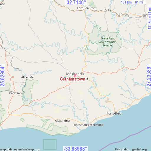
Grahamstown GPS coordinates[2]
33° 18' 15.192" South, 26° 31' 57.936" East
| Map corner | latitude | longitude |
|---|---|---|
| Upper-left | -32.7146°, | 25.82964° |
| Center: | -33.30422°, | 26.53276° |
| Lower-right: | -33.88988°, | 27.23589° |
| Map W x H: | 130.7×130.7 km | = 81.2×81.2mi |
| max Lat: | -22.34881° ⇑86.7% North |
| Grahamstown: | -33.30422° |
| min Lat: | ⇓13.3% South -34.66739° |
| min Long | Grahamstown | max Long |
| 16.8697° | 26.53276° | 32.26762° |
| W 34.5%⇐ | ⇒65.5% E |
Elevation
Elevation of Grahamstown is 551 m = 1808 ft, and this is 418.6 m = 1373 ft below average elevation for this country.
| Max E: |
1873 m = 6145 ft | 72.9% |
| Avg. | 969.6 m = 3181 ft | |
| Grahamstown | 551 m = 1808 ft | |
Min E: |
7 m = 23 ft | 27.1% |
See also: Grahamstown elevation on elevation.city.
Geographical zone
Grahamstown is located in South temperate zone (between Tropic of Capricorn and the Antarctic Circle). Distance of this Southern Tropic circle is 1097.2 km =681.8 mi to North.| Distance of | km | miles | from Grahamstown |
|---|---|---|---|
| Equator | 3703.1 | 2301 | to North |
| Tropic Capricorn | 1097.2 | 681.8 | to North |
| Antarctic Circle | 3698.1 | 2297.9 | to South |
| South Pole | 6304 | 3917.1 | to South |


Nearby cities:
15 places around Grahamstown: (largest is in red/bold)
• Adelaide
69.9 km =43.4 mi,  341°
341°
• Alice
64 km =39.8 mi,  26°
26°
• Bhisho
98.8 km =61.4 mi,  59°
59°
• East London
132.3 km =82.2 mi,  75°
75°
• Fort Beaufort
59.6 km =37 mi,  9°
9°
• Kirkwood
101.8 km =63.3 mi,  264°
264°
• Komga
150.4 km =93.5 mi, 57°
• Peddie
55.2 km =34.3 mi, 77°
• Port Alfred
45.2 km =28.1 mi,  133°
133°
• Port Elizabeth
112 km =69.6 mi,  229°
229°
• Somerset East
109.3 km =67.9 mi,  306°
306°
• Stutterheim
116.5 km =72.4 mi,  45°
45°
• Tarkastad
146.3 km =90.9 mi,  349°
349°
• Uitenhage
116.7 km =72.5 mi,  244°
244°
• Whittlesea
128.4 km =79.8 mi, 12°
Sources, notices
• [Note1] Compared only with cities in South Africa existing in our database
• [Src1] Map data: © OpenStreetMap contributors (CC-BY-SA)
• [Src2] Other city data from geonames.org with taken over terms of usage.
• [Src3] Geographical zone / Annual Mean Temperature by Robert A. Rohde @ Wikipedia
