East London geodata
East London (Eastern Cape) is a seat of a second-order administrative division; located in South Africa in Africa/Johannesburg (GMT+2) time zone. With population of 478,676 people, there are 9 cities with bigger population in this country. Compared to other cities in South Africa, 85% of cities are located further ↑North; 54% of cities are located further ←West and 93.2% of cities have higher elevation than East London. Note1
Administrative division(s):
- Level 1: Eastern Cape
- Level 2: Buffalo City Metropolitan Municipality
- Level 3: Buffalo City


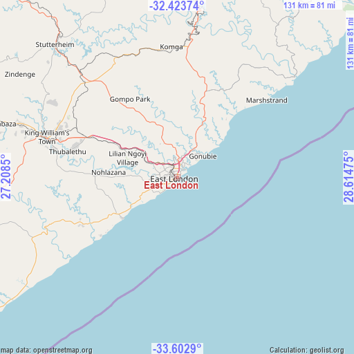
East London GPS coordinates[2]
33° 0' 55.044" South, 27° 54' 41.832" East
| Map corner | latitude | longitude |
|---|---|---|
| Upper-left | -32.42374°, | 27.2085° |
| Center: | -33.01529°, | 27.91162° |
| Lower-right: | -33.6029°, | 28.61475° |
| Map W x H: | 131.1×131.1 km | = 81.5×81.5mi |
| max Lat: | -22.34881° ⇑85% North |
| East London: | -33.01529° |
| min Lat: | ⇓15% South -34.66739° |
| min Long | East London | max Long |
| 16.8697° | 27.91162° | 32.26762° |
| W 54%⇐ | ⇒46% E |
Elevation
Elevation of East London is 48 m = 157 ft, and this is 921.6 m = 3024 ft below average elevation for this country.
| Max E: |
1873 m = 6145 ft | 93.2% |
| Avg. | 969.6 m = 3181 ft | |
| East London | 48 m = 157 ft | |
Min E: |
7 m = 23 ft | 6.8% |
See also: East London elevation on elevation.city.
Geographical zone
East London is located in South temperate zone (between Tropic of Capricorn and the Antarctic Circle). Distance of this Southern Tropic circle is 1065 km =661.8 mi to North.| Distance of | km | miles | from East London |
|---|---|---|---|
| Equator | 3671 | 2281.1 | to North |
| Tropic Capricorn | 1065 | 661.8 | to North |
| Antarctic Circle | 3730.2 | 2317.8 | to South |
| South Pole | 6336.1 | 3937.1 | to South |


Nearby cities:
15 places around East London: (largest is in red/bold)
• Adelaide
154.8 km =96.2 mi,  282°
282°
• Alice
103.7 km =64.4 mi, 284°
• Bhisho
47.6 km =29.6 mi,  293°
293°
• Butterworth
79.3 km =49.3 mi,  16°
16°
• Cofimvaba
117 km =72.7 mi,  344°
344°
• Fort Beaufort
122.3 km =76 mi, 282°
• Grahamstown
132.3 km =82.2 mi,  255°
255°
• Ilinge
141.3 km =87.8 mi,  324°
324°
• Komga
48.8 km =30.3 mi,  357°
357°
• Peddie
77.1 km =47.9 mi,  254°
254°
• Port Alfred
114.7 km =71.3 mi,  236°
236°
• Queensdale
154.4 km =95.9 mi,  325°
325°
• Queenstown
157.8 km =98.1 mi, 321°
• Stutterheim
67.2 km =41.8 mi, 317°
• Whittlesea
138.1 km =85.8 mi,  312°
312°
Sources, notices
• [Note1] Compared only with cities in South Africa existing in our database
• [Src1] Map data: © OpenStreetMap contributors (CC-BY-SA)
• [Src2] Other city data from geonames.org with taken over terms of usage.
• [Src3] Geographical zone / Annual Mean Temperature by Robert A. Rohde @ Wikipedia
