Brits geodata
Brits (North-West) is a seat of a third-order administrative division; located in South Africa in Africa/Johannesburg (GMT+2) time zone. With population of 122,497 people, there are 46 cities with bigger population in this country. Compared to other cities in South Africa, 88.5% of cities are located further ↓South; 51% of cities are located further ←West and 50.4% of cities have lower elevation than Brits. Note1
Administrative division(s):
- Level 1: North-West
- Level 2: Bojanala Platinum District Municipality
- Level 3: Local Municipality of Madibeng


Brits GPS coordinates[2]
25° 38' 5.028" South, 27° 46' 48.792" East
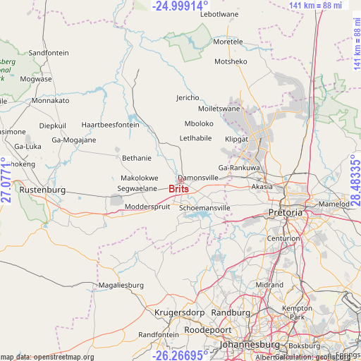
| Map corner | latitude | longitude |
|---|---|---|
| Upper-left | -24.99914°, | 27.0771° |
| Center: | -25.63473°, | 27.78022° |
| Lower-right: | -26.26695°, | 28.48335° |
| Map W x H: | 141×141 km | = 87.6×87.6mi |
| max Lat: | -22.34881° ⇑11.5% North |
| Brits: | -25.63473° |
| min Lat: | ⇓88.5% South -34.66739° |
| min Long | Brits | max Long |
| 16.8697° | 27.78022° | 32.26762° |
| W 51%⇐ | ⇒49% E |
Elevation
Elevation of Brits is 1118 m = 3668 ft, and this is 148.4 m = 487 ft above average elevation for this country.
| Max E: |
1873 m = 6145 ft | 49.6% |
| Brits | 1118 m 3668 ft | |
| Avg. | 969.6 m = 3181 ft | |
Min E: |
7 m = 23 ft | 50.4% |
See also: Brits elevation on elevation.city.
Geographical zone
Brits is located in South temperate zone (between Tropic of Capricorn and the Antarctic Circle). Distance of this Southern Tropic circle is 244.4 km =151.9 mi to North.| Distance of | km | miles | from Brits |
|---|---|---|---|
| Equator | 2850.3 | 1771.1 | to North |
| Tropic Capricorn | 244.4 | 151.9 | to North |
| Antarctic Circle | 4550.9 | 2827.8 | to South |
| South Pole | 7156.7 | 4447 | to South |


Nearby cities:
15 places around Brits: (largest is in red/bold)
• Centurion
47.7 km =29.6 mi,  121°
121°
• Diepsloot
40.5 km =25.2 mi,  145°
145°
• Ga-Rankuwa
21.6 km =13.4 mi,  84°
84°
• Krugersdorp
50.2 km =31.2 mi,  180°
180°
• Mabopane
35.6 km =22.1 mi,  64°
64°
• Maile
54.4 km =33.8 mi,  293°
293°
• Makapanstad
55.6 km =34.5 mi,  38°
38°
• Midrand
52.6 km =32.7 mi,  138°
138°
• Midstream
52.5 km =32.6 mi,  126°
126°
• Muldersdriseloop
45.1 km =28 mi,  172°
172°
• Pretoria
42.6 km =26.5 mi,  106°
106°
• Randburg
55.7 km =34.6 mi,  156°
156°
• Roodepoort
59.4 km =36.9 mi, 171°
• Rustenburg
54.1 km =33.6 mi,  266°
266°
• Tembisa
60.1 km =37.3 mi, 131°
Sources, notices
• [Note1] Compared only with cities in South Africa existing in our database
• [Src1] Map data: © OpenStreetMap contributors (CC-BY-SA)
• [Src2] Other city data from geonames.org with taken over terms of usage.
• [Src3] Geographical zone / Annual Mean Temperature by Robert A. Rohde @ Wikipedia
