Rustenburg geodata
Rustenburg (North-West) is a seat of a third-order administrative division; located in South Africa in Africa/Johannesburg (GMT+2) time zone. With population of 124,064 people, there are 42 cities with bigger population in this country. Compared to other cities in South Africa, 88.2% of cities are located further ↓South; 55.2% of cities are located further →East and 54% of cities have lower elevation than Rustenburg. Note1
Administrative division(s):
- Level 1: North-West
- Level 2: Bojanala Platinum District Municipality
- Level 3: Rustenburg


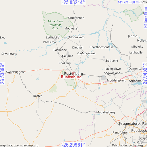
Rustenburg GPS coordinates[2]
25° 40' 3.216" South, 27° 14' 31.488" East
| Map corner | latitude | longitude |
|---|---|---|
| Upper-left | -25.03214°, | 26.53896° |
| Center: | -25.66756°, | 27.24208° |
| Lower-right: | -26.29961°, | 27.94521° |
| Map W x H: | 140.9×140.9 km | = 87.6×87.6mi |
| max Lat: | -22.34881° ⇑11.8% North |
| Rustenburg: | -25.66756° |
| min Lat: | ⇓88.2% South -34.66739° |
| min Long | Rustenburg | max Long |
| 16.8697° | 27.24208° | 32.26762° |
| W 44.8%⇐ | ⇒55.2% E |
Elevation
Elevation of Rustenburg is 1171 m = 3842 ft, and this is 201.4 m = 661 ft above average elevation for this country.
| Max E: |
1873 m = 6145 ft | 46% |
| Rustenburg | 1171 m 3842 ft | |
| Avg. | 969.6 m = 3181 ft | |
Min E: |
7 m = 23 ft | 54% |
See also: Rustenburg elevation on elevation.city.
Geographical zone
Rustenburg is located in South temperate zone (between Tropic of Capricorn and the Antarctic Circle). Distance of this Southern Tropic circle is 248 km =154.1 mi to North.| Distance of | km | miles | from Rustenburg |
|---|---|---|---|
| Equator | 2854 | 1773.4 | to North |
| Tropic Capricorn | 248 | 154.1 | to North |
| Antarctic Circle | 4547.2 | 2825.5 | to South |
| South Pole | 7153.1 | 4444.7 | to South |


Nearby cities:
15 places around Rustenburg: (largest is in red/bold)
• Brits
54.1 km =33.6 mi,  86°
86°
• Carletonville
78.6 km =48.8 mi,  168°
168°
• Diepsloot
82.5 km =51.3 mi,  110°
110°
• Ga-Rankuwa
75.7 km =47 mi, 85°
• Koster
40.8 km =25.4 mi,  237°
237°
• Krugersdorp
70.8 km =44 mi,  131°
131°
• Mabopane
88.2 km =54.8 mi,  77°
77°
• Maile
25.4 km =15.8 mi,  8°
8°
• Mogwase
43.5 km =27 mi,  356°
356°
• Muldersdriseloop
72.4 km =45 mi,  124°
124°
• Randburg
89.5 km =55.6 mi, 121°
• Randfontein
73.6 km =45.7 mi,  141°
141°
• Roodepoort
83.7 km =52 mi, 131°
• Ventersdorp
83.2 km =51.7 mi,  210°
210°
• Westonaria
83.1 km =51.6 mi,  150°
150°
Sources, notices
• [Note1] Compared only with cities in South Africa existing in our database
• [Src1] Map data: © OpenStreetMap contributors (CC-BY-SA)
• [Src2] Other city data from geonames.org with taken over terms of usage.
• [Src3] Geographical zone / Annual Mean Temperature by Robert A. Rohde @ Wikipedia
