Bāzār-e Tālah geodata
Bāzār-e Tālah (Baghlan) is a seat of a second-order administrative division; located in Afghanistan in Asia/Kabul (GMT+4.5) time zone. In our database, there are 93 cities with bigger population. Compared to other cities in Afghanistan, 67.2% of cities are located further ↓South; 53.4% of cities are located further →East and 57.9% of cities have higher elevation than Bāzār-e Tālah. Note1


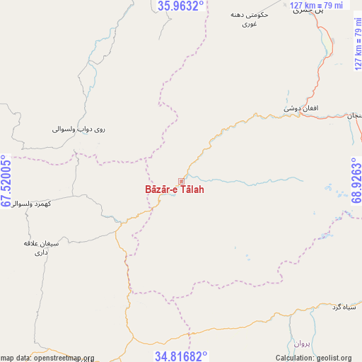
Bāzār-e Tālah GPS coordinates[2]
35° 23' 31.38" North, 68° 13' 23.412" East
| Map corner | latitude | longitude |
|---|---|---|
| Upper-left | 35.9632°, | 67.52005° |
| Center: | 35.39205°, | 68.22317° |
| Lower-right: | 34.81682°, | 68.9263° |
| Map W x H: | 127.5×127.5 km | = 79.2×79.2mi |
| max Lat: | 38.4435° ⇑32.8% North |
| Bāzār-e Tālah: | 35.39205° |
| min Lat: | ⇓67.2% South 30.15° |
| min Long | Bāzār-e Tāla | max Long |
| 61.06667° | 68.22317° | 72.318° |
| W 46.6%⇐ | ⇒53.4% E |
Elevation
Elevation of Bāzār-e Tālah is 1206 m = 3957 ft, and this is 212.4 m = 697 ft below average elevation for this country.
| Max E: |
3068 m = 10066 ft | 57.9% |
| Avg. | 1418.4 m = 4654 ft | |
| Bāzār-e Tālah | 1206 m = 3957 ft | |
Min E: |
254 m = 833 ft | 42.1% |
See also: Afghanistan elevation on elevation.city.
Geographical zone
Bāzār-e Tālah is located in North temperate zone (between Tropic of Cancer and the Arctic Circle). Distance of this Northern Tropic circle is 1329.3 km =826 mi to South.| Distance of | km | miles | from Bāzār-e Tālah |
|---|---|---|---|
| North Pole | 6071.8 | 3772.8 | to North |
| Arctic Circle | 3465.9 | 2153.6 | to North |
| Tropic Cancer | 1329.3 | 826 | to South |
| Equator | 3935.2 | 2445.2 | to South |


Nearby cities:
15 places around Bāzār-e Tālah: (largest is in red/bold)
• Baghlān
93.1 km =57.8 mi,  28°
28°
• Bulōlah
58.6 km =36.4 mi,  192°
192°
• Bāgh-e Maīdān
91.9 km =57.1 mi,  101°
101°
• Bāmyān
72.9 km =45.3 mi,  209°
209°
• Dahan-e Jarf
55.9 km =34.7 mi,  157°
157°
• Dōshī
48.3 km =30 mi,  59°
59°
• Dūāb
41 km =25.5 mi,  297°
297°
• Khinjān
65.2 km =40.5 mi,  70°
70°
• Khudāydād Khēl
54.1 km =33.6 mi,  243°
243°
• Langar
68.8 km =42.8 mi,  346°
346°
• Pul-e Khumrī
75.8 km =47.1 mi,  35°
35°
• Qāshqāl
81.3 km =50.5 mi,  118°
118°
• Rū-ye Sang
54 km =33.6 mi,  261°
261°
• Siyāhgird
71.8 km =44.6 mi,  126°
126°
• Ḩukūmatī Dahanah-ye Ghōrī
62 km =38.5 mi,  22°
22°
Sources, notices
• [Note1] Compared only with cities in Afghanistan existing in our database
• [Src1] Map data: © OpenStreetMap contributors (CC-BY-SA)
• [Src2] Other city data from geonames.org with taken over terms of usage.
• [Src3] Geographical zone / Annual Mean Temperature by Robert A. Rohde @ Wikipedia
