Shaykh Amīr Kêlay geodata
Shaykh Amīr Kêlay (Khowst) is a seat of a second-order administrative division; located in Afghanistan in Asia/Kabul (GMT+4.5) time zone. In our database, there are 93 cities with bigger population. Compared to other cities in Afghanistan, 77.8% of cities are located further ↑North; 80.7% of cities are located further ←West and 57.6% of cities have higher elevation than Shaykh Amīr Kêlay. Note1


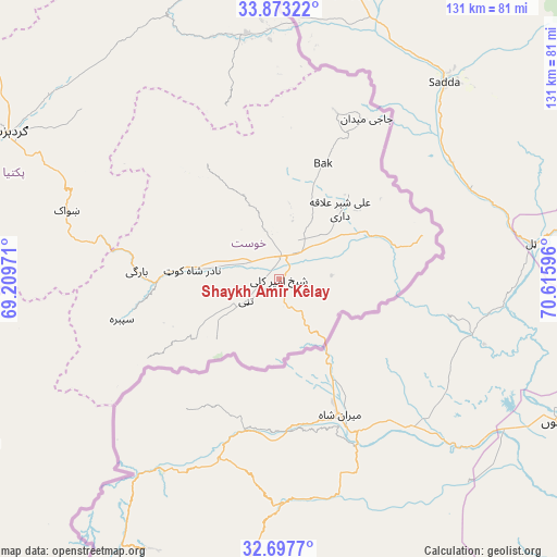
Shaykh Amīr Kêlay GPS coordinates[2]
33° 17' 14.784" North, 69° 54' 46.188" East
| Map corner | latitude | longitude |
|---|---|---|
| Upper-left | 33.87322°, | 69.20971° |
| Center: | 33.28744°, | 69.91283° |
| Lower-right: | 32.6977°, | 70.61596° |
| Map W x H: | 130.7×130.7 km | = 81.2×81.2mi |
| max Lat: | 38.4435° ⇑77.8% North |
| Shaykh Amīr Kêlay: | 33.28744° |
| min Lat: | ⇓22.2% South 30.15° |
| min Long | Shaykh Amīr K� | max Long |
| 61.06667° | 69.91283° | 72.318° |
| W 80.7%⇐ | ⇒19.3% E |
Elevation
Elevation of Shaykh Amīr Kêlay is 1207 m = 3960 ft, and this is 211.4 m = 694 ft below average elevation for this country.
| Max E: |
3068 m = 10066 ft | 57.6% |
| Avg. | 1418.4 m = 4654 ft | |
| Shaykh Amīr Kêlay | 1207 m = 3960 ft | |
Min E: |
254 m = 833 ft | 42.4% |
See also: Afghanistan elevation on elevation.city.
Geographical zone
Shaykh Amīr Kêlay is located in North temperate zone (between Tropic of Cancer and the Arctic Circle). Distance of this Northern Tropic circle is 1095.3 km =680.6 mi to South.| Distance of | km | miles | from Shaykh Amīr Kêlay |
|---|---|---|---|
| North Pole | 6305.8 | 3918.2 | to North |
| Arctic Circle | 3700 | 2299.1 | to North |
| Tropic Cancer | 1095.3 | 680.6 | to South |
| Equator | 3701.2 | 2299.8 | to South |


Nearby cities:
15 places around Shaykh Amīr Kêlay: (largest is in red/bold)
• Dwah Manḏay
30.4 km =18.9 mi,  268°
268°
• Khulbisāt
24.6 km =15.3 mi,  20°
20°
• Khōst
5.8 km =3.6 mi,  6°
6°
• Maīdān Khūlah
42 km =26.1 mi,  343°
343°
• Nīkêh
60.6 km =37.7 mi,  259°
259°
• Salām Khēl
68.8 km =42.8 mi,  308°
308°
• Shwāk
52 km =32.3 mi,  286°
286°
• Spērah
38.2 km =23.7 mi, 255°
• Stêr Giyān
61 km =37.9 mi,  235°
235°
• Tsamkanī
58 km =36 mi,  351°
351°
• Tsapêraī
60.3 km =37.5 mi,  0°
0°
• Wulêswālī Sayyid Karam
67.5 km =41.9 mi, 311°
• Zerok-Alakadari
57.6 km =35.8 mi, 255°
• Zorkot
32.7 km =20.3 mi,  329°
329°
• ‘Alī Shēr ‘Alāqahdārī
21.9 km =13.6 mi,  40°
40°
Sources, notices
• [Note1] Compared only with cities in Afghanistan existing in our database
• [Src1] Map data: © OpenStreetMap contributors (CC-BY-SA)
• [Src2] Other city data from geonames.org with taken over terms of usage.
• [Src3] Geographical zone / Annual Mean Temperature by Robert A. Rohde @ Wikipedia
