Yeghegnadzor geodata
Yeghegnadzor (Vayots Dzor) is a seat of a first-order administrative division; located in Armenia in Asia/Yerevan (GMT+4) time zone. With population of 8,200 people, there are 27 cities with bigger population in this country. Compared to other cities in Armenia, 93% of cities are located further ↑North; 87.3% of cities are located further ←West and 51.9% of cities have higher elevation than Yeghegnadzor. Note1


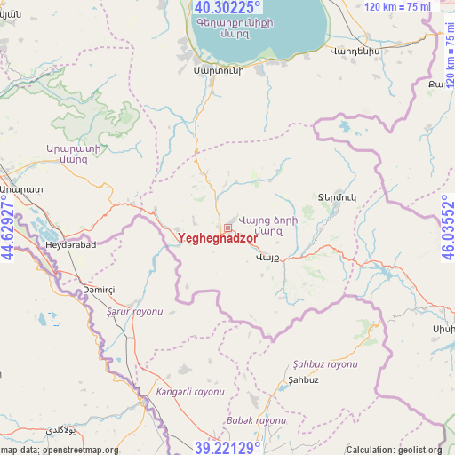
Yeghegnadzor GPS coordinates[2]
39° 45' 50.004" North, 45° 19' 56.604" East
| Map corner | latitude | longitude |
|---|---|---|
| Upper-left | 40.30225°, | 44.62927° |
| Center: | 39.76389°, | 45.33239° |
| Lower-right: | 39.22129°, | 46.03552° |
| Map W x H: | 120.2×120.2 km | = 74.7×74.7mi |
| max Lat: | 41.24358° ⇑93% North |
| Yeghegnadzor: | 39.76389° |
| min Lat: | ⇓7% South 38.90292° |
| min Long | Yeghegnadzor | max Long |
| 43.74722° | 45.33239° | 46.5446° |
| W 87.3%⇐ | ⇒12.7% E |
Elevation
Elevation of Yeghegnadzor is 1242 m = 4075 ft, and this is 59.5 m = 195 ft below average elevation for this country.
| Max E: |
2169 m = 7116 ft | 51.9% |
| Avg. | 1301.5 m = 4270 ft | |
| Yeghegnadzor | 1242 m = 4075 ft | |
Min E: |
440 m = 1444 ft | 48.1% |
See also: Armenia elevation on elevation.city.
Geographical zone
Yeghegnadzor is located in North temperate zone (between Tropic of Cancer and the Arctic Circle). Distance of this Northern Tropic circle is 1815.4 km =1128 mi to South.| Distance of | km | miles | from Yeghegnadzor |
|---|---|---|---|
| North Pole | 5585.7 | 3470.8 | to North |
| Arctic Circle | 2979.8 | 1851.6 | to North |
| Tropic Cancer | 1815.4 | 1128 | to South |
| Equator | 4421.3 | 2747.3 | to South |


Nearby cities:
15 places around Yeghegnadzor: (largest is in red/bold)
• Agarakadzor
3.7 km =2.3 mi,  147°
147°
• Aghavnadzor
9.3 km =5.8 mi,  285°
285°
• Areni
13.8 km =8.6 mi,  247°
247°
• Getap’
2.1 km =1.3 mi,  270°
270°
• Gladzor
2.3 km =1.4 mi,  34°
34°
• Jermuk
30.1 km =18.7 mi,  73°
73°
• Madina
35.4 km =22 mi,  349°
349°
• Malishka
6.5 km =4 mi,  106°
106°
• Rrind
13.2 km =8.2 mi, 268°
• Shatin
8.4 km =5.2 mi,  342°
342°
• Vayk’
14.2 km =8.8 mi,  125°
125°
• Vernashen
4.2 km =2.6 mi,  40°
40°
• Yeghegis
12.1 km =7.5 mi,  7°
7°
• Zangakatun
25.7 km =16 mi,  284°
284°
• Zarrit’ap’
20.7 km =12.9 mi, 132°
In other languages:
- In France: Eghegnazor
- In German: Jeghegnadsor
- In Russian: Ехегнадзор
- In Chinese: 葉海格納佐爾
Sources, notices
• [Note1] Compared only with cities in Armenia existing in our database
• [Src1] Map data: © OpenStreetMap contributors (CC-BY-SA)
• [Src2] Other city data from geonames.org with taken over terms of usage.
• [Src3] Geographical zone / Annual Mean Temperature by Robert A. Rohde @ Wikipedia
