Vernashen geodata
Vernashen (Vayots Dzor) is a populated place; located in Armenia in Asia/Yerevan (GMT+4) time zone. With population of 1,162 people, there are 273 cities with bigger population in this country. Compared to other cities in Armenia, 91.4% of cities are located further ↑North; 89.5% of cities are located further ←West and 65.9% of cities have lower elevation than Vernashen. Note1


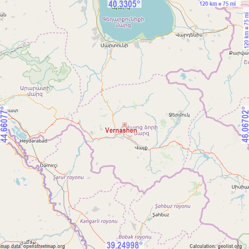
Vernashen GPS coordinates[2]
39° 47' 32.496" North, 45° 21' 50.004" East
| Map corner | latitude | longitude |
|---|---|---|
| Upper-left | 40.3305°, | 44.66077° |
| Center: | 39.79236°, | 45.36389° |
| Lower-right: | 39.24998°, | 46.06702° |
| Map W x H: | 120.1×120.1 km | = 74.6×74.6mi |
| max Lat: | 41.24358° ⇑91.4% North |
| Vernashen: | 39.79236° |
| min Lat: | ⇓8.6% South 38.90292° |
| min Long | Vernashen | max Long |
| 43.74722° | 45.36389° | 46.5446° |
| W 89.5%⇐ | ⇒10.5% E |
Elevation
Elevation of Vernashen is 1543 m = 5062 ft, and this is 241.5 m = 792 ft above average elevation for this country.
| Max E: |
2169 m = 7116 ft | 34.1% |
| Vernashen | 1543 m 5062 ft | |
| Avg. | 1301.5 m = 4270 ft | |
Min E: |
440 m = 1444 ft | 65.9% |
See also: Armenia elevation on elevation.city.
Geographical zone
Vernashen is located in North temperate zone (between Tropic of Cancer and the Arctic Circle). Distance of this Northern Tropic circle is 1818.6 km =1130 mi to South.| Distance of | km | miles | from Vernashen |
|---|---|---|---|
| North Pole | 5582.6 | 3468.9 | to North |
| Arctic Circle | 2976.7 | 1849.6 | to North |
| Tropic Cancer | 1818.6 | 1130 | to South |
| Equator | 4424.5 | 2749.3 | to South |


Nearby cities:
15 places around Vernashen: (largest is in red/bold)
• Agarakadzor
6.3 km =3.9 mi,  186°
186°
• Aghavnadzor
11.6 km =7.2 mi,  266°
266°
• Areni
17.6 km =10.9 mi,  241°
241°
• Getap’
5.7 km =3.5 mi, 236°
• Gladzor
1.9 km =1.2 mi,  227°
227°
• Jermuk
26.7 km =16.6 mi,  78°
78°
• Madina
32.9 km =20.4 mi,  343°
343°
• Malishka
6.2 km =3.9 mi,  144°
144°
• Rrind
16.3 km =10.1 mi,  257°
257°
• Shatin
7.1 km =4.4 mi,  313°
313°
• Vayk’
14.5 km =9 mi, 142°
• Yeghegis
9 km =5.6 mi,  352°
352°
• Yeghegnadzor
4.2 km =2.6 mi,  220°
220°
• Zangakatun
27.7 km =17.2 mi,  276°
276°
• Zarrit’ap’
21.2 km =13.2 mi, 143°
Sources, notices
• [Note1] Compared only with cities in Armenia existing in our database
• [Src1] Map data: © OpenStreetMap contributors (CC-BY-SA)
• [Src2] Other city data from geonames.org with taken over terms of usage.
• [Src3] Geographical zone / Annual Mean Temperature by Robert A. Rohde @ Wikipedia
