Hrazdan geodata
Hrazdan (Kotayk) is a seat of a first-order administrative division; located in Armenia in Asia/Yerevan (GMT+4) time zone. With population of 40,795 people, there are 4 cities with bigger population in this country. Compared to other cities in Armenia, 68.2% of cities are located further ↓South; 69.7% of cities are located further ←West and 78.3% of cities have lower elevation than Hrazdan. Note1


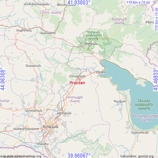
Hrazdan GPS coordinates[2]
40° 29' 50.928" North, 44° 45' 58.32" East
| Map corner | latitude | longitude |
|---|---|---|
| Upper-left | 41.03003°, | 44.06308° |
| Center: | 40.49748°, | 44.7662° |
| Lower-right: | 39.96067°, | 45.46933° |
| Map W x H: | 118.9×118.9 km | = 73.9×73.9mi |
| max Lat: | 41.24358° ⇑31.8% North |
| Hrazdan: | 40.49748° |
| min Lat: | ⇓68.2% South 38.90292° |
| min Long | Hrazdan | max Long |
| 43.74722° | 44.7662° | 46.5446° |
| W 69.7%⇐ | ⇒30.3% E |
Elevation
Elevation of Hrazdan is 1762 m = 5781 ft, and this is 460.5 m = 1511 ft above average elevation for this country.
| Max E: |
2169 m = 7116 ft | 21.7% |
| Hrazdan | 1762 m 5781 ft | |
| Avg. | 1301.5 m = 4270 ft | |
Min E: |
440 m = 1444 ft | 78.3% |
See also: Hrazdan elevation on elevation.city.
Geographical zone
Hrazdan is located in North temperate zone (between Tropic of Cancer and the Arctic Circle). Distance of this Northern Tropic circle is 1897 km =1178.7 mi to South.| Distance of | km | miles | from Hrazdan |
|---|---|---|---|
| North Pole | 5504.2 | 3420.2 | to North |
| Arctic Circle | 2898.3 | 1800.9 | to North |
| Tropic Cancer | 1897 | 1178.7 | to South |
| Equator | 4502.9 | 2798 | to South |


Nearby cities:
15 places around Hrazdan: (largest is in red/bold)
• Aghavnadzor
11.1 km =6.9 mi,  327°
327°
• Arzakan
14.4 km =8.9 mi,  248°
248°
• Bjni
10.7 km =6.6 mi, 246°
• Ddmashen
9.4 km =5.8 mi,  30°
30°
• Fantan
13.3 km =8.3 mi,  210°
210°
• Gagarin
10 km =6.2 mi,  61°
61°
• Geghamavan
12.6 km =7.8 mi, 55°
• Lchashen
14.1 km =8.8 mi,  80°
80°
• Lerrnanist
4.1 km =2.5 mi,  146°
146°
• Meghradzor
15.5 km =9.6 mi,  321°
321°
• Sevan
15.8 km =9.8 mi,  69°
69°
• Solak
6.3 km =3.9 mi,  232°
232°
• Tsaghkadzor
5.5 km =3.4 mi, 315°
• Varser
13.6 km =8.5 mi, 61°
• Zovaber
8 km =5 mi,  14°
14°
Sources, notices
• [Note1] Compared only with cities in Armenia existing in our database
• [Src1] Map data: © OpenStreetMap contributors (CC-BY-SA)
• [Src2] Other city data from geonames.org with taken over terms of usage.
• [Src3] Geographical zone / Annual Mean Temperature by Robert A. Rohde @ Wikipedia
