Ddmashen geodata
Ddmashen (Gegharkunik) is a populated place; located in Armenia in Asia/Yerevan (GMT+4) time zone. With population of 2,157 people, there are 139 cities with bigger population in this country. Compared to other cities in Armenia, 72.3% of cities are located further ↓South; 72.3% of cities are located further ←West and 81.5% of cities have lower elevation than Ddmashen. Note1


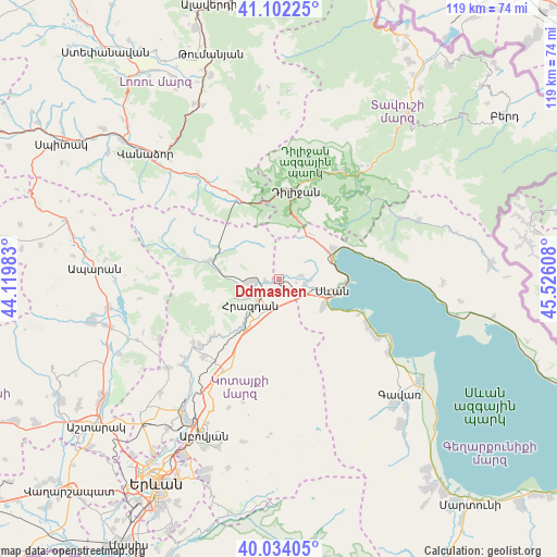
Ddmashen GPS coordinates[2]
40° 34' 13.008" North, 44° 49' 22.62" East
| Map corner | latitude | longitude |
|---|---|---|
| Upper-left | 41.10225°, | 44.11983° |
| Center: | 40.57028°, | 44.82295° |
| Lower-right: | 40.03405°, | 45.52608° |
| Map W x H: | 118.8×118.8 km | = 73.8×73.8mi |
| max Lat: | 41.24358° ⇑27.7% North |
| Ddmashen: | 40.57028° |
| min Lat: | ⇓72.3% South 38.90292° |
| min Long | Ddmashen | max Long |
| 43.74722° | 44.82295° | 46.5446° |
| W 72.3%⇐ | ⇒27.7% E |
Elevation
Elevation of Ddmashen is 1798 m = 5899 ft, and this is 496.5 m = 1629 ft above average elevation for this country.
| Max E: |
2169 m = 7116 ft | 18.5% |
| Ddmashen | 1798 m 5899 ft | |
| Avg. | 1301.5 m = 4270 ft | |
Min E: |
440 m = 1444 ft | 81.5% |
See also: Armenia elevation on elevation.city.
Geographical zone
Ddmashen is located in North temperate zone (between Tropic of Cancer and the Arctic Circle). Distance of this Northern Tropic circle is 1905.1 km =1183.8 mi to South.| Distance of | km | miles | from Ddmashen |
|---|---|---|---|
| North Pole | 5496.1 | 3415.1 | to North |
| Arctic Circle | 2890.2 | 1795.9 | to North |
| Tropic Cancer | 1905.1 | 1183.8 | to South |
| Equator | 4511 | 2803 | to South |


Nearby cities:
15 places around Ddmashen: (largest is in red/bold)
• Aghavnadzor
10.8 km =6.7 mi,  276°
276°
• Dilijan
19.2 km =11.9 mi,  6°
6°
• Fioletovo
19.1 km =11.9 mi,  332°
332°
• Gagarin
5.2 km =3.2 mi,  130°
130°
• Geghamavan
5.6 km =3.5 mi,  98°
98°
• Hrazdan
9.4 km =5.8 mi,  210°
210°
• Lchashen
10.7 km =6.6 mi,  121°
121°
• Lerrnanist
11.8 km =7.3 mi,  192°
192°
• Meghradzor
15 km =9.3 mi,  285°
285°
• Sevan
10.4 km =6.5 mi, 104°
• Solak
15.5 km =9.6 mi,  219°
219°
• Tsaghkadzor
9.6 km =6 mi,  244°
244°
• Tsovagyugh
13.6 km =8.5 mi,  58°
58°
• Varser
7.4 km =4.6 mi, 102°
• Zovaber
2.8 km =1.7 mi,  261°
261°
Sources, notices
• [Note1] Compared only with cities in Armenia existing in our database
• [Src1] Map data: © OpenStreetMap contributors (CC-BY-SA)
• [Src2] Other city data from geonames.org with taken over terms of usage.
• [Src3] Geographical zone / Annual Mean Temperature by Robert A. Rohde @ Wikipedia
