Fioletovo geodata
Fioletovo (Lori) is a populated place; located in Armenia in Asia/Yerevan (GMT+4) time zone. With population of 1,264 people, there are 256 cities with bigger population in this country. Compared to other cities in Armenia, 79.3% of cities are located further ↓South; 67.5% of cities are located further ←West and 75.5% of cities have lower elevation than Fioletovo. Note1


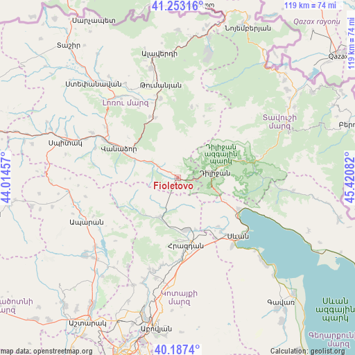
Fioletovo GPS coordinates[2]
40° 43' 20.676" North, 44° 43' 3.684" East
| Map corner | latitude | longitude |
|---|---|---|
| Upper-left | 41.25316°, | 44.01457° |
| Center: | 40.72241°, | 44.71769° |
| Lower-right: | 40.1874°, | 45.42082° |
| Map W x H: | 118.5×118.5 km | = 73.6×73.6mi |
| max Lat: | 41.24358° ⇑20.7% North |
| Fioletovo: | 40.72241° |
| min Lat: | ⇓79.3% South 38.90292° |
| min Long | Fioletovo | max Long |
| 43.74722° | 44.71769° | 46.5446° |
| W 67.5%⇐ | ⇒32.5% E |
Elevation
Elevation of Fioletovo is 1686 m = 5531 ft, and this is 384.5 m = 1261 ft above average elevation for this country.
| Max E: |
2169 m = 7116 ft | 24.5% |
| Fioletovo | 1686 m 5531 ft | |
| Avg. | 1301.5 m = 4270 ft | |
Min E: |
440 m = 1444 ft | 75.5% |
See also: Armenia elevation on elevation.city.
Geographical zone
Fioletovo is located in North temperate zone (between Tropic of Cancer and the Arctic Circle). Distance of this Northern Tropic circle is 1922 km =1194.3 mi to South.| Distance of | km | miles | from Fioletovo |
|---|---|---|---|
| North Pole | 5479.2 | 3404.6 | to North |
| Arctic Circle | 2873.3 | 1785.4 | to North |
| Tropic Cancer | 1922 | 1194.3 | to South |
| Equator | 4527.9 | 2813.5 | to South |


Nearby cities:
15 places around Fioletovo: (largest is in red/bold)
• Aghavnadzor
15.7 km =9.8 mi,  186°
186°
• Ddmashen
19.1 km =11.9 mi,  152°
152°
• Dilijan
11.4 km =7.1 mi,  79°
79°
• Geghamavan
22.9 km =14.2 mi,  140°
140°
• Gugark’
17.5 km =10.9 mi,  301°
301°
• Haghartsin
22 km =13.7 mi,  74°
74°
• Margahovit
3.1 km =1.9 mi,  294°
294°
• Meghradzor
14.1 km =8.8 mi,  203°
203°
• Shahumyan
15.6 km =9.7 mi, 291°
• Tsaghkadzor
21.1 km =13.1 mi,  179°
179°
• Tsovagyugh
22.8 km =14.2 mi,  115°
115°
• Vahagni
22.5 km =14 mi,  335°
335°
• Vanadzor
20.9 km =13 mi, 295°
• Yeghegnut
21.4 km =13.3 mi, 340°
• Zovaber
18.4 km =11.4 mi,  160°
160°
Sources, notices
• [Note1] Compared only with cities in Armenia existing in our database
• [Src1] Map data: © OpenStreetMap contributors (CC-BY-SA)
• [Src2] Other city data from geonames.org with taken over terms of usage.
• [Src3] Geographical zone / Annual Mean Temperature by Robert A. Rohde @ Wikipedia
