Dsegh geodata
Dsegh (Lori) is a populated place; located in Armenia in Asia/Yerevan (GMT+4) time zone. With population of 2,484 people, there are 117 cities with bigger population in this country. Compared to other cities in Armenia, 93% of cities are located further ↓South; 61.5% of cities are located further ←West and 52.5% of cities have higher elevation than Dsegh. Note1


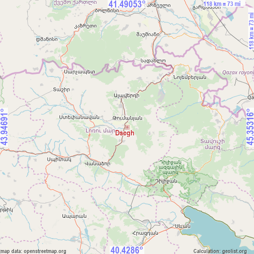
Dsegh GPS coordinates[2]
40° 57' 42.12" North, 44° 39' 0.108" East
| Map corner | latitude | longitude |
|---|---|---|
| Upper-left | 41.49053°, | 43.94691° |
| Center: | 40.9617°, | 44.65003° |
| Lower-right: | 40.4286°, | 45.35316° |
| Map W x H: | 118.1×118.1 km | = 73.4×73.4mi |
| max Lat: | 41.24358° ⇑7% North |
| Dsegh: | 40.9617° |
| min Lat: | ⇓93% South 38.90292° |
| min Long | Dsegh | max Long |
| 43.74722° | 44.65003° | 46.5446° |
| W 61.5%⇐ | ⇒38.5% E |
Elevation
Elevation of Dsegh is 1216 m = 3990 ft, and this is 85.5 m = 281 ft below average elevation for this country.
| Max E: |
2169 m = 7116 ft | 52.5% |
| Avg. | 1301.5 m = 4270 ft | |
| Dsegh | 1216 m = 3990 ft | |
Min E: |
440 m = 1444 ft | 47.5% |
See also: Armenia elevation on elevation.city.
Geographical zone
Dsegh is located in North temperate zone (between Tropic of Cancer and the Arctic Circle). Distance of this Northern Tropic circle is 1948.6 km =1210.8 mi to South.| Distance of | km | miles | from Dsegh |
|---|---|---|---|
| North Pole | 5452.5 | 3388 | to North |
| Arctic Circle | 2846.7 | 1768.9 | to North |
| Tropic Cancer | 1948.6 | 1210.8 | to South |
| Equator | 4554.5 | 2830 | to South |


Nearby cities:
15 places around Dsegh: (largest is in red/bold)
• Agarak
16.2 km =10.1 mi,  289°
289°
• Alaverdi
15.2 km =9.4 mi,  7°
7°
• Bazum
20.5 km =12.7 mi,  239°
239°
• Darpas
23.5 km =14.6 mi,  233°
233°
• Gugark’
19.8 km =12.3 mi,  207°
207°
• Gyulagarak
15 km =9.3 mi,  272°
272°
• Lorut
10.6 km =6.6 mi,  104°
104°
• Odzun
10.6 km =6.6 mi,  343°
343°
• Shahumyan
22.5 km =14 mi,  202°
202°
• Step’anavan
22.9 km =14.2 mi,  283°
283°
• Urrut
24.3 km =15.1 mi,  298°
298°
• Vahagni
7 km =4.3 mi, 209°
• Vanadzor
21.9 km =13.6 mi,  216°
216°
• Vardablur
11.9 km =7.4 mi, 274°
• Yeghegnut
6.7 km =4.2 mi,  193°
193°
Sources, notices
• [Note1] Compared only with cities in Armenia existing in our database
• [Src1] Map data: © OpenStreetMap contributors (CC-BY-SA)
• [Src2] Other city data from geonames.org with taken over terms of usage.
• [Src3] Geographical zone / Annual Mean Temperature by Robert A. Rohde @ Wikipedia
