Solak geodata
Solak (Kotayk) is a populated place; located in Armenia in Asia/Yerevan (GMT+4) time zone. With population of 2,295 people, there are 129 cities with bigger population in this country. Compared to other cities in Armenia, 66.6% of cities are located further ↓South; 67.2% of cities are located further ←West and 73.6% of cities have lower elevation than Solak. Note1


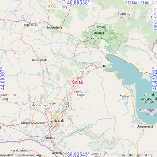
Solak GPS coordinates[2]
40° 27' 45.072" North, 44° 42' 25.524" East
| Map corner | latitude | longitude |
|---|---|---|
| Upper-left | 40.99535°, | 44.00397° |
| Center: | 40.46252°, | 44.70709° |
| Lower-right: | 39.92543°, | 45.41022° |
| Map W x H: | 119×119 km | = 73.9×73.9mi |
| max Lat: | 41.24358° ⇑33.4% North |
| Solak: | 40.46252° |
| min Lat: | ⇓66.6% South 38.90292° |
| min Long | Solak | max Long |
| 43.74722° | 44.70709° | 46.5446° |
| W 67.2%⇐ | ⇒32.8% E |
Elevation
Elevation of Solak is 1658 m = 5440 ft, and this is 356.5 m = 1170 ft above average elevation for this country.
| Max E: |
2169 m = 7116 ft | 26.4% |
| Solak | 1658 m 5440 ft | |
| Avg. | 1301.5 m = 4270 ft | |
Min E: |
440 m = 1444 ft | 73.6% |
See also: Armenia elevation on elevation.city.
Geographical zone
Solak is located in North temperate zone (between Tropic of Cancer and the Arctic Circle). Distance of this Northern Tropic circle is 1893.1 km =1176.3 mi to South.| Distance of | km | miles | from Solak |
|---|---|---|---|
| North Pole | 5508.1 | 3422.6 | to North |
| Arctic Circle | 2902.2 | 1803.3 | to North |
| Tropic Cancer | 1893.1 | 1176.3 | to South |
| Equator | 4499 | 2795.5 | to South |


Nearby cities:
15 places around Solak: (largest is in red/bold)
• Aghavnadzor
13.3 km =8.3 mi,  355°
355°
• Aragyugh
15.3 km =9.5 mi,  244°
244°
• Argel
13.1 km =8.1 mi,  223°
223°
• Arzakan
8.5 km =5.3 mi,  260°
260°
• Bjni
4.8 km =3 mi, 264°
• Buzhakan
15.9 km =9.9 mi,  267°
267°
• Ddmashen
15.5 km =9.6 mi,  39°
39°
• Fantan
7.8 km =4.8 mi,  193°
193°
• Gagarin
16.2 km =10.1 mi,  57°
57°
• Hrazdan
6.3 km =3.9 mi,  52°
52°
• Kaputan
15.3 km =9.5 mi,  182°
182°
• Lerrnanist
7.2 km =4.5 mi,  86°
86°
• Meghradzor
16.6 km =10.3 mi,  343°
343°
• Tsaghkadzor
7.9 km =4.9 mi,  8°
8°
• Zovaber
13.6 km =8.5 mi,  31°
31°
Sources, notices
• [Note1] Compared only with cities in Armenia existing in our database
• [Src1] Map data: © OpenStreetMap contributors (CC-BY-SA)
• [Src2] Other city data from geonames.org with taken over terms of usage.
• [Src3] Geographical zone / Annual Mean Temperature by Robert A. Rohde @ Wikipedia
