Lerrnanist geodata
Lerrnanist (Kotayk) is a populated place; located in Armenia in Asia/Yerevan (GMT+4) time zone. With population of 2,511 people, there are 114 cities with bigger population in this country. Compared to other cities in Armenia, 66.9% of cities are located further ↓South; 71.3% of cities are located further ←West and 87.3% of cities have lower elevation than Lerrnanist. Note1


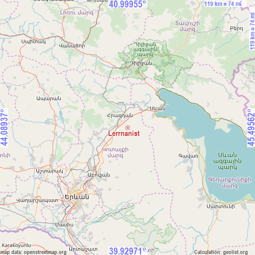
Lerrnanist GPS coordinates[2]
40° 28' 0.336" North, 44° 47' 32.964" East
| Map corner | latitude | longitude |
|---|---|---|
| Upper-left | 40.99955°, | 44.08937° |
| Center: | 40.46676°, | 44.79249° |
| Lower-right: | 39.92971°, | 45.49562° |
| Map W x H: | 119×119 km | = 73.9×73.9mi |
| max Lat: | 41.24358° ⇑33.1% North |
| Lerrnanist: | 40.46676° |
| min Lat: | ⇓66.9% South 38.90292° |
| min Long | Lerrnanist | max Long |
| 43.74722° | 44.79249° | 46.5446° |
| W 71.3%⇐ | ⇒28.7% E |
Elevation
Elevation of Lerrnanist is 1922 m = 6306 ft, and this is 620.5 m = 2036 ft above average elevation for this country.
| Max E: |
2169 m = 7116 ft | 12.7% |
| Lerrnanist | 1922 m 6306 ft | |
| Avg. | 1301.5 m = 4270 ft | |
Min E: |
440 m = 1444 ft | 87.3% |
See also: Armenia elevation on elevation.city.
Geographical zone
Lerrnanist is located in North temperate zone (between Tropic of Cancer and the Arctic Circle). Distance of this Northern Tropic circle is 1893.6 km =1176.6 mi to South.| Distance of | km | miles | from Lerrnanist |
|---|---|---|---|
| North Pole | 5507.6 | 3422.3 | to North |
| Arctic Circle | 2901.7 | 1803 | to North |
| Tropic Cancer | 1893.6 | 1176.6 | to South |
| Equator | 4499.5 | 2795.9 | to South |


Nearby cities:
15 places around Lerrnanist: (largest is in red/bold)
• Aghavnadzor
15.2 km =9.4 mi,  327°
327°
• Arzakan
15.7 km =9.8 mi,  263°
263°
• Bjni
12.1 km =7.5 mi,  265°
265°
• Ddmashen
11.8 km =7.3 mi,  12°
12°
• Fantan
12.1 km =7.5 mi,  228°
228°
• Gagarin
10.5 km =6.5 mi,  38°
38°
• Geghamavan
13.4 km =8.3 mi, 37°
• Hrazdan
4.1 km =2.5 mi, 326°
• Kaputan
17.6 km =10.9 mi,  206°
206°
• Lchashen
13.1 km =8.1 mi,  63°
63°
• Sevan
15.5 km =9.6 mi,  54°
54°
• Solak
7.2 km =4.5 mi, 266°
• Tsaghkadzor
9.5 km =5.9 mi,  320°
320°
• Varser
13.9 km =8.6 mi, 44°
• Zovaber
11.1 km =6.9 mi,  359°
359°
Sources, notices
• [Note1] Compared only with cities in Armenia existing in our database
• [Src1] Map data: © OpenStreetMap contributors (CC-BY-SA)
• [Src2] Other city data from geonames.org with taken over terms of usage.
• [Src3] Geographical zone / Annual Mean Temperature by Robert A. Rohde @ Wikipedia
