Sunchales geodata
Sunchales (Santa Fe) is a populated place; located in Argentina in America/Argentina/Cordoba (GMT-3) time zone. With population of 18,757 people, there are 197 cities with bigger population in this country. Compared to other cities in Argentina, 60.4% of cities are located further ↓South; 57.5% of cities are located further ←West and 63% of cities have higher elevation than Sunchales. Note1


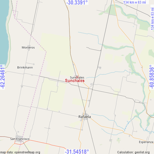
Sunchales GPS coordinates[2]
30° 56' 38.544" South, 61° 33' 41.328" West
| Map corner | latitude | longitude |
|---|---|---|
| Upper-left | -30.3391°, | -62.26461° |
| Center: | -30.94404°, | -61.56148° |
| Lower-right: | -31.54518°, | -60.85836° |
| Map W x H: | 134.1×134.1 km | = 83.3×83.3mi |
| max Lat: | -21.94467° ⇑39.6% North |
| Sunchales: | -30.94404° |
| min Lat: | ⇓60.4% South -54.81084° |
| min Long | Sunchales | max Long |
| -72.88605° | -61.56148° | -53.64581° |
| W 57.5%⇐ | ⇒42.5% E |
Elevation
Elevation of Sunchales is 98 m = 322 ft, and this is 251.3 m = 824 ft below average elevation for this country.
| Max E: |
4040 m = 13255 ft | 63% |
| Avg. | 349.3 m = 1146 ft | |
| Sunchales | 98 m = 322 ft | |
Min E: |
-2 m = -7 ft | 37% |
See also: Argentina elevation on elevation.city.
Geographical zone
Sunchales is located in South temperate zone (between Tropic of Capricorn and the Antarctic Circle). Distance of this Southern Tropic circle is 834.7 km =518.7 mi to North.| Distance of | km | miles | from Sunchales |
|---|---|---|---|
| Equator | 3440.7 | 2138 | to North |
| Tropic Capricorn | 834.7 | 518.7 | to North |
| Antarctic Circle | 3960.5 | 2460.9 | to South |
| South Pole | 6566.4 | 4080.2 | to South |


Nearby cities:
15 places around Sunchales: (largest is in red/bold)
• Altos de Chipión
74 km =46 mi,  268°
268°
• Arrufó
80.7 km =50.1 mi,  348°
348°
• Bella Italia
40.2 km =25 mi,  159°
159°
• Brinkmann
46.2 km =28.7 mi,  280°
280°
• Devoto
87.4 km =54.3 mi,  234°
234°
• Esperanza
82.1 km =51 mi,  133°
133°
• Laguna Paiva
94.8 km =58.9 mi,  114°
114°
• Morteros
49.1 km =30.5 mi,  301°
301°
• Porteña
48.8 km =30.3 mi,  260°
260°
• Rafaela
34.8 km =21.6 mi,  168°
168°
• San Cristóbal
77 km =47.8 mi,  23°
23°
• San Francisco
73.2 km =45.5 mi,  222°
222°
• San Justo
94.1 km =58.5 mi,  79°
79°
• Sastre
95 km =59 mi,  195°
195°
• Villa Trinidad
86.6 km =53.8 mi,  339°
339°
Sources, notices
• [Note1] Compared only with cities in Argentina existing in our database
• [Src1] Map data: © OpenStreetMap contributors (CC-BY-SA)
• [Src2] Other city data from geonames.org with taken over terms of usage.
• [Src3] Geographical zone / Annual Mean Temperature by Robert A. Rohde @ Wikipedia
