Arrufó geodata
Arrufó (Santa Fe) is a populated place; located in Argentina in America/Argentina/Cordoba (GMT-3) time zone. With population of 2,190 people, there are 619 cities with bigger population in this country. Compared to other cities in Argentina, 64.1% of cities are located further ↓South; 56.8% of cities are located further ←West and 64.7% of cities have higher elevation than Arrufó. Note1


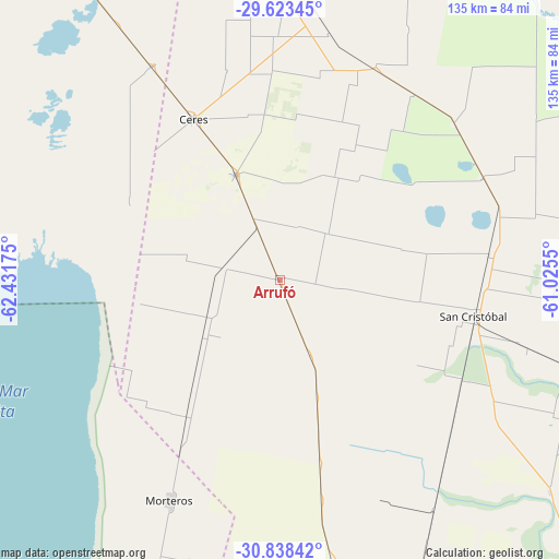
Arrufó GPS coordinates[2]
30° 13' 58.116" South, 61° 43' 43.032" West
| Map corner | latitude | longitude |
|---|---|---|
| Upper-left | -29.62345°, | -62.43175° |
| Center: | -30.23281°, | -61.72862° |
| Lower-right: | -30.83842°, | -61.0255° |
| Map W x H: | 135.1×135.1 km | = 83.9×83.9mi |
| max Lat: | -21.94467° ⇑35.9% North |
| Arrufó: | -30.23281° |
| min Lat: | ⇓64.1% South -54.81084° |
| min Long | Arrufó | max Long |
| -72.88605° | -61.72862° | -53.64581° |
| W 56.8%⇐ | ⇒43.2% E |
Elevation
Elevation of Arrufó is 94 m = 308 ft, and this is 255.3 m = 838 ft below average elevation for this country.
| Max E: |
4040 m = 13255 ft | 64.7% |
| Avg. | 349.3 m = 1146 ft | |
| Arrufó | 94 m = 308 ft | |
Min E: |
-2 m = -7 ft | 35.3% |
See also: Argentina elevation on elevation.city.
Geographical zone
Arrufó is located in South temperate zone (between Tropic of Capricorn and the Antarctic Circle). Distance of this Southern Tropic circle is 755.7 km =469.6 mi to North.| Distance of | km | miles | from Arrufó |
|---|---|---|---|
| Equator | 3361.6 | 2088.8 | to North |
| Tropic Capricorn | 755.7 | 469.6 | to North |
| Antarctic Circle | 4039.6 | 2510.1 | to South |
| South Pole | 6645.5 | 4129.3 | to South |


Nearby cities:
15 places around Arrufó: (largest is in red/bold)
• Altos de Chipión
99.3 km =61.7 mi,  215°
215°
• Balnearia
124.5 km =77.4 mi,  226°
226°
• Bella Italia
120.5 km =74.9 mi,  165°
165°
• Brinkmann
76.4 km =47.5 mi,  202°
202°
• Ceres
44.3 km =27.5 mi,  331°
331°
• Hersilia
27.6 km =17.1 mi,  336°
336°
• Miramar
118.6 km =73.7 mi, 230°
• Morteros
59.2 km =36.8 mi,  205°
205°
• Porteña
92.7 km =57.6 mi, 200°
• Rafaela
115.5 km =71.8 mi, 168°
• San Cristóbal
48 km =29.8 mi,  100°
100°
• Selva
60.1 km =37.3 mi, 329°
• Sunchales
80.7 km =50.1 mi, 168°
• Tostado
111.3 km =69.2 mi,  357°
357°
• Villa Trinidad
14.3 km =8.9 mi,  278°
278°
Sources, notices
• [Note1] Compared only with cities in Argentina existing in our database
• [Src1] Map data: © OpenStreetMap contributors (CC-BY-SA)
• [Src2] Other city data from geonames.org with taken over terms of usage.
• [Src3] Geographical zone / Annual Mean Temperature by Robert A. Rohde @ Wikipedia
