Rufino geodata
Rufino (Santa Fe) is a populated place; located in Argentina in America/Argentina/Cordoba (GMT-3) time zone. With population of 18,361 people, there are 200 cities with bigger population in this country. Compared to other cities in Argentina, 69.7% of cities are located further ↑North; 50.6% of cities are located further ←West and 56.4% of cities have higher elevation than Rufino. Note1


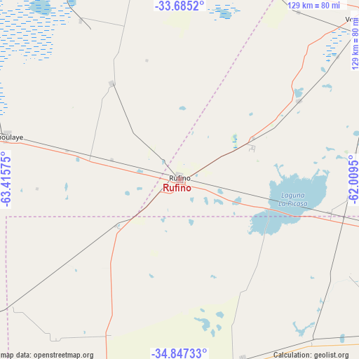
Rufino GPS coordinates[2]
34° 16' 5.772" South, 62° 42' 45.432" West
| Map corner | latitude | longitude |
|---|---|---|
| Upper-left | -33.6852°, | -63.41575° |
| Center: | -34.26827°, | -62.71262° |
| Lower-right: | -34.84733°, | -62.0095° |
| Map W x H: | 129.2×129.2 km | = 80.3×80.3mi |
| max Lat: | -21.94467° ⇑69.7% North |
| Rufino: | -34.26827° |
| min Lat: | ⇓30.3% South -54.81084° |
| min Long | Rufino | max Long |
| -72.88605° | -62.71262° | -53.64581° |
| W 50.6%⇐ | ⇒49.4% E |
Elevation
Elevation of Rufino is 118 m = 387 ft, and this is 231.3 m = 759 ft below average elevation for this country.
| Max E: |
4040 m = 13255 ft | 56.4% |
| Avg. | 349.3 m = 1146 ft | |
| Rufino | 118 m = 387 ft | |
Min E: |
-2 m = -7 ft | 43.6% |
See also: Argentina elevation on elevation.city.
Geographical zone
Rufino is located in South temperate zone (between Tropic of Capricorn and the Antarctic Circle). Distance of this Southern Tropic circle is 1204.4 km =748.4 mi to North.| Distance of | km | miles | from Rufino |
|---|---|---|---|
| Equator | 3810.3 | 2367.6 | to North |
| Tropic Capricorn | 1204.4 | 748.4 | to North |
| Antarctic Circle | 3590.9 | 2231.3 | to South |
| South Pole | 6196.8 | 3850.5 | to South |


Nearby cities:
15 places around Rufino: (largest is in red/bold)
• Alejo Ledesma
74.1 km =46 mi,  6°
6°
• Arias
75.1 km =46.7 mi,  22°
22°
• Buchardo
88.8 km =55.2 mi,  235°
235°
• Canals
79.8 km =49.6 mi,  348°
348°
• Cavanagh
94.6 km =58.8 mi, 21°
• Florentino Ameghino
67.9 km =42.2 mi,  160°
160°
• General Pinto
93.3 km =58 mi,  126°
126°
• General Villegas
89.3 km =55.5 mi,  197°
197°
• Guatimozín
93.2 km =57.9 mi, 15°
• La Cesira
42.6 km =26.5 mi,  325°
325°
• Laboulaye
64.4 km =40 mi,  284°
284°
• Serrano
79 km =49.1 mi,  253°
253°
• Tres Algarrobos
103.2 km =64.1 mi,  183°
183°
• Venado Tuerto
89.9 km =55.9 mi,  49°
49°
• Viamonte
68 km =42.3 mi, 328°
Sources, notices
• [Note1] Compared only with cities in Argentina existing in our database
• [Src1] Map data: © OpenStreetMap contributors (CC-BY-SA)
• [Src2] Other city data from geonames.org with taken over terms of usage.
• [Src3] Geographical zone / Annual Mean Temperature by Robert A. Rohde @ Wikipedia
