Olta geodata
Olta (La Rioja) is a seat of a second-order administrative division; located in Argentina in America/Argentina/La_Rioja (GMT-3) time zone. In our database, there are 785 cities with bigger population. Compared to other cities in Argentina, 62.5% of cities are located further ↓South; 83.7% of cities are located further →East and 78.2% of cities have lower elevation than Olta. Note1


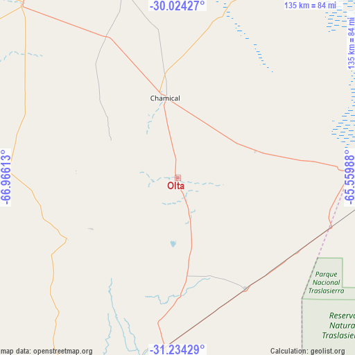
Olta GPS coordinates[2]
30° 37' 52.212" South, 66° 15' 46.8" West
| Map corner | latitude | longitude |
|---|---|---|
| Upper-left | -30.02427°, | -66.96613° |
| Center: | -30.63117°, | -66.263° |
| Lower-right: | -31.23429°, | -65.55988° |
| Map W x H: | 134.5×134.5 km | = 83.6×83.6mi |
| max Lat: | -21.94467° ⇑37.5% North |
| Olta: | -30.63117° |
| min Lat: | ⇓62.5% South -54.81084° |
| min Long | Olta | max Long |
| -72.88605° | -66.263° | -53.64581° |
| W 16.3%⇐ | ⇒83.7% E |
Elevation
Elevation of Olta is 520 m = 1706 ft, and this is 170.7 m = 560 ft above average elevation for this country.
| Max E: |
4040 m = 13255 ft | 21.8% |
| Olta | 520 m 1706 ft | |
| Avg. | 349.3 m = 1146 ft | |
Min E: |
-2 m = -7 ft | 78.2% |
See also: Argentina elevation on elevation.city.
Geographical zone
Olta is located in South temperate zone (between Tropic of Capricorn and the Antarctic Circle). Distance of this Southern Tropic circle is 799.9 km =497 mi to North.| Distance of | km | miles | from Olta |
|---|---|---|---|
| Equator | 3405.9 | 2116.3 | to North |
| Tropic Capricorn | 799.9 | 497 | to North |
| Antarctic Circle | 3995.3 | 2482.6 | to South |
| South Pole | 6601.2 | 4101.8 | to South |


Nearby cities:
15 places around Olta: (largest is in red/bold)
• Castro Barros
51.6 km =32.1 mi,  83°
83°
• Chamical
30.5 km =19 mi,  350°
350°
• Chepes
85.1 km =52.9 mi,  201°
201°
• Cruz del Eje
139.9 km =86.9 mi,  94°
94°
• La Rioja
147 km =91.3 mi,  337°
337°
• Malanzán
38.3 km =23.8 mi,  239°
239°
• Milagro
49.3 km =30.6 mi,  148°
148°
• Patquía
88.1 km =54.7 mi,  317°
317°
• Salsacate
135.4 km =84.1 mi,  124°
124°
• San Agustín de Valle Fértil
115.3 km =71.6 mi,  269°
269°
• San Carlos
126.3 km =78.5 mi, 118°
• Serrezuela
83.8 km =52.1 mi, 90°
• Tama
29 km =18 mi,  298°
298°
• Ulapes
104.8 km =65.1 mi,  178°
178°
• Villa de Soto
123.3 km =76.6 mi,  101°
101°
Sources, notices
• [Note1] Compared only with cities in Argentina existing in our database
• [Src1] Map data: © OpenStreetMap contributors (CC-BY-SA)
• [Src2] Other city data from geonames.org with taken over terms of usage.
• [Src3] Geographical zone / Annual Mean Temperature by Robert A. Rohde @ Wikipedia
