La Rioja geodata
La Rioja is a seat of a first-order administrative division; located in Argentina in America/Argentina/La_Rioja (GMT-3) time zone. With population of 162,620 people, there are 27 cities with bigger population in this country. Compared to other cities in Argentina, 66.5% of cities are located further ↓South; 85.3% of cities are located further →East and 77.3% of cities have lower elevation than La Rioja. Note1


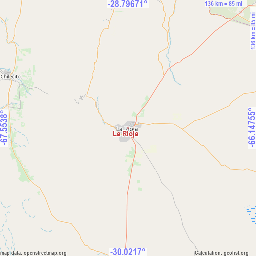
La Rioja GPS coordinates[2]
29° 24' 39.78" South, 66° 51' 2.412" West
| Map corner | latitude | longitude |
|---|---|---|
| Upper-left | -28.79671°, | -67.5538° |
| Center: | -29.41105°, | -66.85067° |
| Lower-right: | -30.0217°, | -66.14755° |
| Map W x H: | 136.2×136.2 km | = 84.6×84.6mi |
| max Lat: | -21.94467° ⇑33.5% North |
| La Rioja: | -29.41105° |
| min Lat: | ⇓66.5% South -54.81084° |
| min Long | La Rioja | max Long |
| -72.88605° | -66.85067° | -53.64581° |
| W 14.7%⇐ | ⇒85.3% E |
Elevation
Elevation of La Rioja is 502 m = 1647 ft, and this is 152.7 m = 501 ft above average elevation for this country.
| Max E: |
4040 m = 13255 ft | 22.7% |
| La Rioja | 502 m 1647 ft | |
| Avg. | 349.3 m = 1146 ft | |
Min E: |
-2 m = -7 ft | 77.3% |
See also: La Rioja elevation on elevation.city.
Geographical zone
La Rioja is located in South temperate zone (between Tropic of Capricorn and the Antarctic Circle). Distance of this Southern Tropic circle is 664.3 km =412.8 mi to North.| Distance of | km | miles | from La Rioja |
|---|---|---|---|
| Equator | 3270.2 | 2032 | to North |
| Tropic Capricorn | 664.3 | 412.8 | to North |
| Antarctic Circle | 4131 | 2566.9 | to South |
| South Pole | 6736.9 | 4186.1 | to South |


Nearby cities:
15 places around La Rioja: (largest is in red/bold)
• Aimogasta
94.6 km =58.8 mi,  2°
2°
• Aminga
63.1 km =39.2 mi,  352°
352°
• Arauco
92.5 km =57.5 mi, 3°
• Capayán
105.4 km =65.5 mi,  47°
47°
• Chamical
117.5 km =73 mi,  153°
153°
• Chilecito
68.6 km =42.6 mi,  293°
293°
• Chumbicha
86.1 km =53.5 mi,  44°
44°
• Famatina
84.7 km =52.6 mi,  309°
309°
• Huillapima
114 km =70.8 mi, 48°
• Patquía
70.8 km =44 mi,  182°
182°
• Pomán
128.6 km =79.9 mi,  28°
28°
• San Blas de los Sauces
113.7 km =70.6 mi, 348°
• Sañogasta
43.5 km =27 mi,  323°
323°
• Tama
125.8 km =78.2 mi,  165°
165°
• Villa Bustos
21.5 km =13.4 mi, 310°
Sources, notices
• [Note1] Compared only with cities in Argentina existing in our database
• [Src1] Map data: © OpenStreetMap contributors (CC-BY-SA)
• [Src2] Other city data from geonames.org with taken over terms of usage.
• [Src3] Geographical zone / Annual Mean Temperature by Robert A. Rohde @ Wikipedia
