Waidhofen an der Thaya geodata
Waidhofen an der Thaya (Lower Austria) is a seat of a third-order administrative division; located in Austria in Europe/Vienna (GMT+2) time zone. With population of 4,280 people, there are 237 cities with bigger population in this country. Compared to other cities in Austria, 99.4% of cities are located further ↓South; 59.7% of cities are located further ←West and 56.4% of cities have lower elevation than Waidhofen an der Thaya. Note1
Administrative division(s):
- Level 1: Lower Austria
- Level 2: Politischer Bezirk Waidhofen an der Thaya
- Level 3: Waidhofen an der Thaya


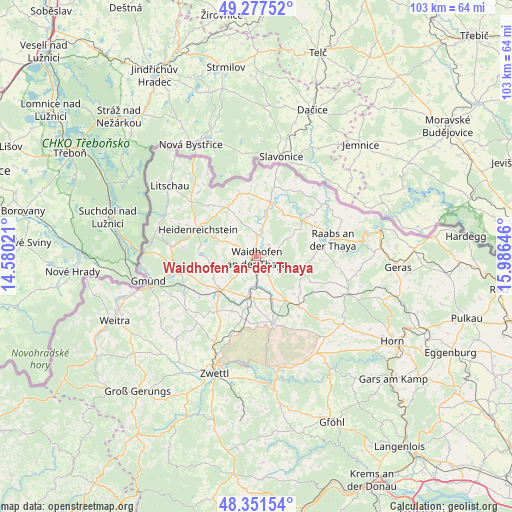
Waidhofen an der Thaya GPS coordinates[2]
48° 49' 0.012" North, 15° 16' 59.988" East
| Map corner | latitude | longitude |
|---|---|---|
| Upper-left | 49.27752°, | 14.58021° |
| Center: | 48.81667°, | 15.28333° |
| Lower-right: | 48.35154°, | 15.98646° |
| Map W x H: | 103×103 km | = 64×64mi |
| max Lat: | 48.98333° ⇑0.6% North |
| Waidhofen an der Thaya: | 48.81667° |
| min Lat: | ⇓99.4% South 46.48841° |
| min Long | Waidhofen an de | max Long |
| 9.57802° | 15.28333° | 17.1° |
| W 59.7%⇐ | ⇒40.3% E |
Elevation
Elevation of Waidhofen an der Thaya is 493 m = 1617 ft, and this is 12.5 m = 41 ft below average elevation for this country.
| Max E: |
2140 m = 7021 ft | 43.6% |
| Avg. | 505.5 m = 1658 ft | |
| Waidhofen an der Thaya | 493 m = 1617 ft | |
Min E: |
118 m = 387 ft | 56.4% |
See also: Austria elevation on elevation.city.
Geographical zone
Waidhofen an der Thaya is located in North temperate zone (between Tropic of Cancer and the Arctic Circle). Distance of this North polar circle is 1973.3 km =1226.2 mi to North.| Distance of | km | miles | from Waidhofen an der Thaya |
|---|---|---|---|
| North Pole | 4579.2 | 2845.4 | to North |
| Arctic Circle | 1973.3 | 1226.2 | to North |
| Tropic Cancer | 2822 | 1753.5 | to South |
| Equator | 5427.9 | 3372.7 | to South |


Nearby cities:
15 places around Waidhofen an der Thaya: (largest is in red/bold)
• Allentsteig
13.7 km =8.5 mi,  166°
166°
• Alt-Dietmanns
7.9 km =4.9 mi,  110°
110°
• Dobersberg
11.3 km =7 mi,  14°
14°
• Echsenbach
12.1 km =7.5 mi,  203°
203°
• Gastern
9.8 km =6.1 mi,  331°
331°
• Groß-Siegharts
9.3 km =5.8 mi, 107°
• Göpfritz an der Wild
13.4 km =8.3 mi,  139°
139°
• Heidenreichstein
13.4 km =8.3 mi,  294°
294°
• Karlstein
11.3 km =7 mi,  49°
49°
• Kautzen
13 km =8.1 mi,  345°
345°
• Schwarzenau
8.2 km =5.1 mi,  192°
192°
• Thaya
4.3 km =2.7 mi, 5°
• Vitis
9.7 km =6 mi,  229°
229°
• Waldkirchen an der Thaya
13.9 km =8.6 mi,  20°
20°
• Windigsteig
5.6 km =3.5 mi,  180°
180°
Sources, notices
• [Note1] Compared only with cities in Austria existing in our database
• [Src1] Map data: © OpenStreetMap contributors (CC-BY-SA)
• [Src2] Other city data from geonames.org with taken over terms of usage.
• [Src3] Geographical zone / Annual Mean Temperature by Robert A. Rohde @ Wikipedia
