Allentsteig geodata
Allentsteig (Lower Austria) is a seat of a third-order administrative division; located in Austria in Europe/Vienna (GMT+2) time zone. With population of 1,383 people, there are 910 cities with bigger population in this country. Compared to other cities in Austria, 98.1% of cities are located further ↓South; 61% of cities are located further ←West and 64.3% of cities have lower elevation than Allentsteig. Note1
Administrative division(s):
- Level 1: Lower Austria
- Level 2: Politischer Bezirk Zwettl
- Level 3: Allentsteig


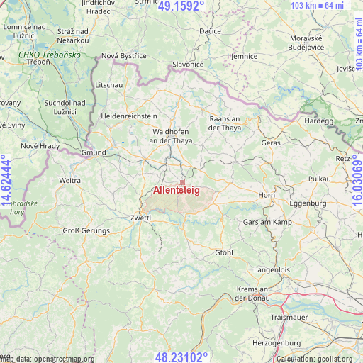
Allentsteig GPS coordinates[2]
48° 41' 50.1" North, 15° 19' 39.216" East
| Map corner | latitude | longitude |
|---|---|---|
| Upper-left | 49.1592°, | 14.62444° |
| Center: | 48.69725°, | 15.32756° |
| Lower-right: | 48.23102°, | 16.03069° |
| Map W x H: | 103.2×103.2 km | = 64.1×64.1mi |
| max Lat: | 48.98333° ⇑1.9% North |
| Allentsteig: | 48.69725° |
| min Lat: | ⇓98.1% South 46.48841° |
| min Long | Allentsteig | max Long |
| 9.57802° | 15.32756° | 17.1° |
| W 61%⇐ | ⇒39% E |
Elevation
Elevation of Allentsteig is 547 m = 1795 ft, and this is 41.5 m = 136 ft above average elevation for this country.
| Max E: |
2140 m = 7021 ft | 35.7% |
| Allentsteig | 547 m 1795 ft | |
| Avg. | 505.5 m = 1658 ft | |
Min E: |
118 m = 387 ft | 64.3% |
See also: Austria elevation on elevation.city.
Geographical zone
Allentsteig is located in North temperate zone (between Tropic of Cancer and the Arctic Circle). Distance of this North polar circle is 1986.5 km =1234.4 mi to North.| Distance of | km | miles | from Allentsteig |
|---|---|---|---|
| North Pole | 4592.4 | 2853.6 | to North |
| Arctic Circle | 1986.5 | 1234.4 | to North |
| Tropic Cancer | 2808.7 | 1745.2 | to South |
| Equator | 5414.6 | 3364.5 | to South |


Nearby cities:
15 places around Allentsteig: (largest is in red/bold)
• Alt-Dietmanns
11.4 km =7.1 mi,  21°
21°
• Brunn an der Wild
14.1 km =8.8 mi,  91°
91°
• Echsenbach
8.4 km =5.2 mi,  284°
284°
• Groß-Siegharts
11.9 km =7.4 mi,  28°
28°
• Göpfritz an der Wild
6.3 km =3.9 mi,  60°
60°
• Hirschbach
15.7 km =9.8 mi,  289°
289°
• Krumau am Kamp
15 km =9.3 mi,  143°
143°
• Rastenfeld
13.8 km =8.6 mi,  178°
178°
• Rudmanns
13.8 km =8.6 mi,  220°
220°
• Röhrenbach
13.7 km =8.5 mi,  112°
112°
• Schwarzenau
7.3 km =4.5 mi,  315°
315°
• Vitis
12.7 km =7.9 mi,  303°
303°
• Waidhofen an der Thaya
13.7 km =8.5 mi,  346°
346°
• Windigsteig
8.4 km =5.2 mi,  337°
337°
• Zwettl Stadt
15.5 km =9.6 mi,  229°
229°
Sources, notices
• [Note1] Compared only with cities in Austria existing in our database
• [Src1] Map data: © OpenStreetMap contributors (CC-BY-SA)
• [Src2] Other city data from geonames.org with taken over terms of usage.
• [Src3] Geographical zone / Annual Mean Temperature by Robert A. Rohde @ Wikipedia
