Groß-Siegharts geodata
Groß-Siegharts (Lower Austria) is a seat of a third-order administrative division; located in Austria in Europe/Vienna (GMT+2) time zone. With population of 1,992 people, there are 617 cities with bigger population in this country. Compared to other cities in Austria, 99.3% of cities are located further ↓South; 63% of cities are located further ←West and 61.4% of cities have lower elevation than Groß-Siegharts. Note1
Administrative division(s):
- Level 1: Lower Austria
- Level 2: Politischer Bezirk Waidhofen an der Thaya
- Level 3: Groß-Siegharts


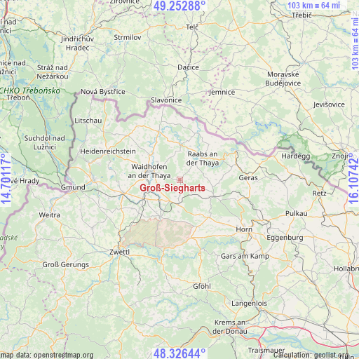
Groß-Siegharts GPS coordinates[2]
48° 47' 30.48" North, 15° 24' 15.444" East
| Map corner | latitude | longitude |
|---|---|---|
| Upper-left | 49.25288°, | 14.70117° |
| Center: | 48.7918°, | 15.40429° |
| Lower-right: | 48.32644°, | 16.10742° |
| Map W x H: | 103×103 km | = 64×64mi |
| max Lat: | 48.98333° ⇑0.7% North |
| Groß-Siegharts: | 48.7918° |
| min Lat: | ⇓99.3% South 46.48841° |
| min Long | Groß-Siegharts | max Long |
| 9.57802° | 15.40429° | 17.1° |
| W 63%⇐ | ⇒37% E |
Elevation
Elevation of Groß-Siegharts is 527 m = 1729 ft, and this is 21.5 m = 71 ft above average elevation for this country.
| Max E: |
2140 m = 7021 ft | 38.6% |
| Groß-Siegharts | 527 m 1729 ft | |
| Avg. | 505.5 m = 1658 ft | |
Min E: |
118 m = 387 ft | 61.4% |
See also: Austria elevation on elevation.city.
Geographical zone
Groß-Siegharts is located in North temperate zone (between Tropic of Cancer and the Arctic Circle). Distance of this North polar circle is 1976 km =1227.8 mi to North.| Distance of | km | miles | from Groß-Siegharts |
|---|---|---|---|
| North Pole | 4581.9 | 2847.1 | to North |
| Arctic Circle | 1976 | 1227.8 | to North |
| Tropic Cancer | 2819.2 | 1751.8 | to South |
| Equator | 5425.1 | 3371 | to South |


Nearby cities:
15 places around Groß-Siegharts: (largest is in red/bold)
• Allentsteig
11.9 km =7.4 mi,  208°
208°
• Alt-Dietmanns
1.5 km =0.9 mi,  272°
272°
• Brunn an der Wild
13.8 km =8.6 mi,  141°
141°
• Dobersberg
15 km =9.3 mi,  336°
336°
• Echsenbach
16.1 km =10 mi,  238°
238°
• Göpfritz an der Wild
7.4 km =4.6 mi,  181°
181°
• Japons
12 km =7.5 mi,  89°
89°
• Karlstein
10.2 km =6.3 mi,  358°
358°
• Raabs an der Thaya
9.5 km =5.9 mi,  47°
47°
• Schwarzenau
11.9 km =7.4 mi, 243°
• Thaya
11 km =6.8 mi,  309°
309°
• Vitis
16.6 km =10.3 mi,  257°
257°
• Waidhofen an der Thaya
9.3 km =5.8 mi,  287°
287°
• Waldkirchen an der Thaya
16.2 km =10.1 mi,  345°
345°
• Windigsteig
9.3 km =5.8 mi,  252°
252°
Sources, notices
• [Note1] Compared only with cities in Austria existing in our database
• [Src1] Map data: © OpenStreetMap contributors (CC-BY-SA)
• [Src2] Other city data from geonames.org with taken over terms of usage.
• [Src3] Geographical zone / Annual Mean Temperature by Robert A. Rohde @ Wikipedia
