Tragwein geodata
Tragwein (Upper Austria) is a populated place; located in Austria in Europe/Vienna (GMT+2) time zone. With population of 1,534 people, there are 823 cities with bigger population in this country. Compared to other cities in Austria, 87.4% of cities are located further ↓South; 51.3% of cities are located further →East and 54.9% of cities have lower elevation than Tragwein. Note1
Administrative division(s):
- Level 1: Upper Austria
- Level 2: Politischer Bezirk Freistadt
- Level 3: Tragwein


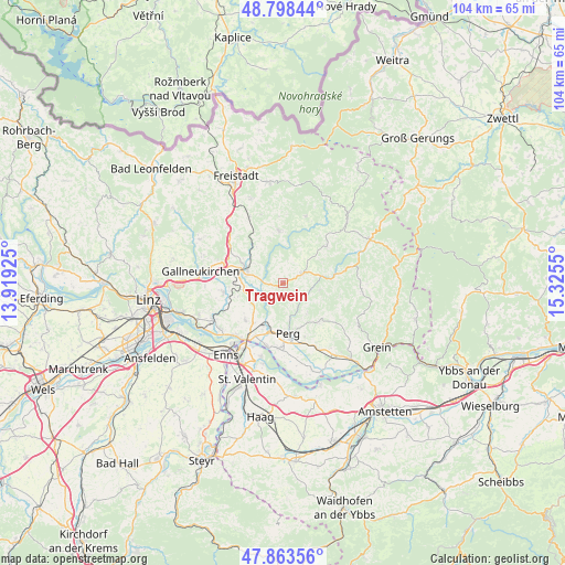
Tragwein GPS coordinates[2]
48° 19' 59.304" North, 14° 37' 20.532" East
| Map corner | latitude | longitude |
|---|---|---|
| Upper-left | 48.79844°, | 13.91925° |
| Center: | 48.33314°, | 14.62237° |
| Lower-right: | 47.86356°, | 15.3255° |
| Map W x H: | 103.9×103.9 km | = 64.6×64.6mi |
| max Lat: | 48.98333° ⇑12.6% North |
| Tragwein: | 48.33314° |
| min Lat: | ⇓87.4% South 46.48841° |
| min Long | Tragwein | max Long |
| 9.57802° | 14.62237° | 17.1° |
| W 48.7%⇐ | ⇒51.3% E |
Elevation
Elevation of Tragwein is 484 m = 1588 ft, and this is 21.5 m = 71 ft below average elevation for this country.
| Max E: |
2140 m = 7021 ft | 45.1% |
| Avg. | 505.5 m = 1658 ft | |
| Tragwein | 484 m = 1588 ft | |
Min E: |
118 m = 387 ft | 54.9% |
See also: Austria elevation on elevation.city.
Geographical zone
Tragwein is located in North temperate zone (between Tropic of Cancer and the Arctic Circle). Distance of this North polar circle is 2027 km =1259.5 mi to North.| Distance of | km | miles | from Tragwein |
|---|---|---|---|
| North Pole | 4632.9 | 2878.7 | to North |
| Arctic Circle | 2027 | 1259.5 | to North |
| Tropic Cancer | 2768.2 | 1720.1 | to South |
| Equator | 5374.1 | 3339.3 | to South |


Nearby cities:
15 places around Tragwein: (largest is in red/bold)
• Allerheiligen im Mühlkreis
4 km =2.5 mi,  148°
148°
• Bad Zell
3.9 km =2.4 mi,  63°
63°
• Doppl
6.9 km =4.3 mi,  215°
215°
• Grünbichl
7.6 km =4.7 mi,  283°
283°
• Gutau
9.4 km =5.8 mi,  355°
355°
• Hagenberg im Mühlkreis
8.7 km =5.4 mi,  296°
296°
• Loitzenberg
8.5 km =5.3 mi, 217°
• Münzbach
9.8 km =6.1 mi,  138°
138°
• Perg
9.3 km =5.8 mi,  174°
174°
• Pregarten
7.1 km =4.4 mi,  289°
289°
• Schwertberg
7.2 km =4.5 mi,  202°
202°
• Unterjosefstal
5.7 km =3.5 mi, 217°
• Wartberg ob der Aist
8.6 km =5.3 mi, 280°
• Wasserburg
7.9 km =4.9 mi,  214°
214°
• Windhaag bei Perg
6.8 km =4.2 mi, 140°
Sources, notices
• [Note1] Compared only with cities in Austria existing in our database
• [Src1] Map data: © OpenStreetMap contributors (CC-BY-SA)
• [Src2] Other city data from geonames.org with taken over terms of usage.
• [Src3] Geographical zone / Annual Mean Temperature by Robert A. Rohde @ Wikipedia
