Spitz geodata
Spitz (Lower Austria) is a seat of a third-order administrative division; located in Austria in Europe/Vienna (GMT+2) time zone. With population of 1,270 people, there are 996 cities with bigger population in this country. Compared to other cities in Austria, 89.3% of cities are located further ↓South; 63.1% of cities are located further ←West and 88.8% of cities have higher elevation than Spitz. Note1


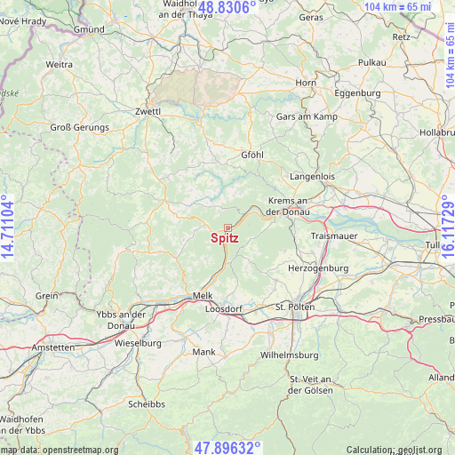
Spitz GPS coordinates[2]
48° 21' 56.16" North, 15° 24' 50.976" East
| Map corner | latitude | longitude |
|---|---|---|
| Upper-left | 48.8306°, | 14.71104° |
| Center: | 48.3656°, | 15.41416° |
| Lower-right: | 47.89632°, | 16.11729° |
| Map W x H: | 103.9×103.9 km | = 64.6×64.6mi |
| max Lat: | 48.98333° ⇑10.7% North |
| Spitz: | 48.3656° |
| min Lat: | ⇓89.3% South 46.48841° |
| min Long | Spitz | max Long |
| 9.57802° | 15.41416° | 17.1° |
| W 63.1%⇐ | ⇒36.9% E |
Elevation
Elevation of Spitz is 223 m = 732 ft, and this is 282.5 m = 927 ft below average elevation for this country.
| Max E: |
2140 m = 7021 ft | 88.8% |
| Avg. | 505.5 m = 1658 ft | |
| Spitz | 223 m = 732 ft | |
Min E: |
118 m = 387 ft | 11.2% |
See also: Austria elevation on elevation.city.
Geographical zone
Spitz is located in North temperate zone (between Tropic of Cancer and the Arctic Circle). Distance of this North polar circle is 2023.4 km =1257.3 mi to North.| Distance of | km | miles | from Spitz |
|---|---|---|---|
| North Pole | 4629.3 | 2876.5 | to North |
| Arctic Circle | 2023.4 | 1257.3 | to North |
| Tropic Cancer | 2771.8 | 1722.3 | to South |
| Equator | 5377.8 | 3341.6 | to South |


Nearby cities:
15 places around Spitz: (largest is in red/bold)
• Aggsbach
8 km =5 mi,  185°
185°
• Dürnstein
8.5 km =5.3 mi,  66°
66°
• Egelsee
12.4 km =7.7 mi,  62°
62°
• Gansbach
7.9 km =4.9 mi,  147°
147°
• Gerolding
12.9 km =8 mi,  179°
179°
• Maria Laach am Jauerling
8.5 km =5.3 mi,  216°
216°
• Mautern
12.5 km =7.8 mi,  75°
75°
• Mühldorf
5.1 km =3.2 mi,  281°
281°
• Raxendorf
10.5 km =6.5 mi,  254°
254°
• Senftenberg
12.5 km =7.8 mi,  53°
53°
• Stein an der Donau
13 km =8.1 mi, 71°
• Unterbergern
10 km =6.2 mi,  89°
89°
• Weinzierl am Walde
7.5 km =4.7 mi,  10°
10°
• Weiten
13.8 km =8.6 mi,  235°
235°
• Weißenkirchen in der Wachau
5.4 km =3.4 mi, 48°
Sources, notices
• [Note1] Compared only with cities in Austria existing in our database
• [Src1] Map data: © OpenStreetMap contributors (CC-BY-SA)
• [Src2] Other city data from geonames.org with taken over terms of usage.
• [Src3] Geographical zone / Annual Mean Temperature by Robert A. Rohde @ Wikipedia
