Horn geodata
Horn (Lower Austria) is a seat of a third-order administrative division; located in Austria in Europe/Vienna (GMT+2) time zone. With population of 5,494 people, there are 172 cities with bigger population in this country. Compared to other cities in Austria, 97.6% of cities are located further ↓South; 70.7% of cities are located further ←West and 74.3% of cities have higher elevation than Horn. Note1


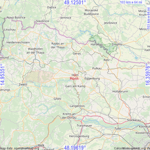
Horn GPS coordinates[2]
48° 39' 45.864" North, 15° 39' 23.868" East
| Map corner | latitude | longitude |
|---|---|---|
| Upper-left | 49.12501°, | 14.95351° |
| Center: | 48.66274°, | 15.65663° |
| Lower-right: | 48.19619°, | 16.35976° |
| Map W x H: | 103.3×103.3 km | = 64.2×64.2mi |
| max Lat: | 48.98333° ⇑2.4% North |
| Horn: | 48.66274° |
| min Lat: | ⇓97.6% South 46.48841° |
| min Long | Horn | max Long |
| 9.57802° | 15.65663° | 17.1° |
| W 70.7%⇐ | ⇒29.3% E |
Elevation
Elevation of Horn is 307 m = 1007 ft, and this is 198.5 m = 651 ft below average elevation for this country.
| Max E: |
2140 m = 7021 ft | 74.3% |
| Avg. | 505.5 m = 1658 ft | |
| Horn | 307 m = 1007 ft | |
Min E: |
118 m = 387 ft | 25.7% |
See also: Austria elevation on elevation.city.
Geographical zone
Horn is located in North temperate zone (between Tropic of Cancer and the Arctic Circle). Distance of this North polar circle is 1990.4 km =1236.8 mi to North.| Distance of | km | miles | from Horn |
|---|---|---|---|
| North Pole | 4596.3 | 2856 | to North |
| Arctic Circle | 1990.4 | 1236.8 | to North |
| Tropic Cancer | 2804.9 | 1742.9 | to South |
| Equator | 5410.8 | 3362.1 | to South |


Nearby cities:
15 places around Horn: (largest is in red/bold)
• Altenburg
5 km =3.1 mi,  250°
250°
• Brunn an der Wild
10.6 km =6.6 mi,  289°
289°
• Eggenburg
12.2 km =7.6 mi,  102°
102°
• Frauenhofen
2.4 km =1.5 mi,  298°
298°
• Gars am Kamp
8.2 km =5.1 mi,  181°
181°
• Geras
15 km =9.3 mi,  4°
4°
• Japons
15.8 km =9.8 mi,  335°
335°
• Maissau
16.2 km =10.1 mi,  128°
128°
• Pernegg
8.4 km =5.2 mi, 339°
• Pulkau
15.7 km =9.8 mi,  72°
72°
• Röhrenbach
11.6 km =7.2 mi,  262°
262°
• Röschitz
12 km =7.5 mi, 100°
• Sankt Leonhard am Hornerwald
11.4 km =7.1 mi,  232°
232°
• Sigmundsherberg
7.2 km =4.5 mi, 71°
• Wolfshoferamt
9.6 km =6 mi,  223°
223°
Sources, notices
• [Note1] Compared only with cities in Austria existing in our database
• [Src1] Map data: © OpenStreetMap contributors (CC-BY-SA)
• [Src2] Other city data from geonames.org with taken over terms of usage.
• [Src3] Geographical zone / Annual Mean Temperature by Robert A. Rohde @ Wikipedia
