Japons geodata
Japons (Lower Austria) is a seat of a third-order administrative division; located in Austria in Europe/Vienna (GMT+2) time zone. With population of 234 people, there are 2825 cities with bigger population in this country. Compared to other cities in Austria, 99.3% of cities are located further ↓South; 67.6% of cities are located further ←West and 58.9% of cities have lower elevation than Japons. Note1


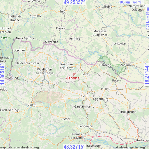
Japons GPS coordinates[2]
48° 47' 33" North, 15° 34' 5.916" East
| Map corner | latitude | longitude |
|---|---|---|
| Upper-left | 49.25357°, | 14.86519° |
| Center: | 48.7925°, | 15.56831° |
| Lower-right: | 48.32715°, | 16.27144° |
| Map W x H: | 103×103 km | = 64×64mi |
| max Lat: | 48.98333° ⇑0.7% North |
| Japons: | 48.7925° |
| min Lat: | ⇓99.3% South 46.48841° |
| min Long | Japons | max Long |
| 9.57802° | 15.56831° | 17.1° |
| W 67.6%⇐ | ⇒32.4% E |
Elevation
Elevation of Japons is 510 m = 1673 ft, and this is 4.5 m = 15 ft above average elevation for this country.
| Max E: |
2140 m = 7021 ft | 41.1% |
| Japons | 510 m 1673 ft | |
| Avg. | 505.5 m = 1658 ft | |
Min E: |
118 m = 387 ft | 58.9% |
See also: Austria elevation on elevation.city.
Geographical zone
Japons is located in North temperate zone (between Tropic of Cancer and the Arctic Circle). Distance of this North polar circle is 1976 km =1227.8 mi to North.| Distance of | km | miles | from Japons |
|---|---|---|---|
| North Pole | 4581.8 | 2847 | to North |
| Arctic Circle | 1976 | 1227.8 | to North |
| Tropic Cancer | 2819.3 | 1751.8 | to South |
| Equator | 5425.2 | 3371.1 | to South |


Nearby cities:
15 places around Japons: (largest is in red/bold)
• Alt-Dietmanns
13.5 km =8.4 mi,  269°
269°
• Altenburg
16.2 km =10.1 mi,  173°
173°
• Brunn an der Wild
11.5 km =7.1 mi,  197°
197°
• Drosendorf
9.2 km =5.7 mi,  24°
24°
• Frauenhofen
14 km =8.7 mi,  161°
161°
• Geras
7.7 km =4.8 mi,  86°
86°
• Groß-Siegharts
12 km =7.5 mi, 269°
• Göpfritz an der Wild
14.3 km =8.9 mi,  238°
238°
• Horn
15.8 km =9.8 mi, 155°
• Karlstein
15.9 km =9.9 mi,  309°
309°
• Langau
11.6 km =7.2 mi,  67°
67°
• Pernegg
7.5 km =4.7 mi,  151°
151°
• Raabs an der Thaya
8.1 km =5 mi,  321°
321°
• Röhrenbach
16.6 km =10.3 mi, 197°
• Weitersfeld
18 km =11.2 mi, 94°
Sources, notices
• [Note1] Compared only with cities in Austria existing in our database
• [Src1] Map data: © OpenStreetMap contributors (CC-BY-SA)
• [Src2] Other city data from geonames.org with taken over terms of usage.
• [Src3] Geographical zone / Annual Mean Temperature by Robert A. Rohde @ Wikipedia
