Goomalling geodata
Goomalling (Western Australia) is a populated place; located in Australia in Australia/Perth (GMT+8) time zone. With population of 552 people, there are 4700 cities with bigger population in this country. Compared to other cities in Australia, 70% of cities are located further ↓South; 90.7% of cities are located further →East and 85.2% of cities have lower elevation than Goomalling. Note1


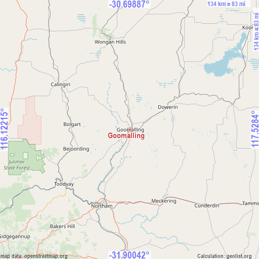
Goomalling GPS coordinates[2]
31° 18' 5.616" South, 116° 49' 30.972" East
| Map corner | latitude | longitude |
|---|---|---|
| Upper-left | -30.69887°, | 116.12215° |
| Center: | -31.30156°, | 116.82527° |
| Lower-right: | -31.90042°, | 117.5284° |
| Map W x H: | 133.6×133.6 km | = 83×83mi |
| max Lat: | -10.58257° ⇑30% North |
| Goomalling: | -31.30156° |
| min Lat: | ⇓70% South -43.31423° |
| min Long | Goomalling | max Long |
| 113.53327° | 116.82527° | 153.61246° |
| W 9.3%⇐ | ⇒90.7% E |
Elevation
Elevation of Goomalling is 251 m = 823 ft, and this is 129 m = 423 ft above average elevation for this country.
| Max E: |
1715 m = 5627 ft | 14.8% |
| Goomalling | 251 m 823 ft | |
| Avg. | 122 m = 400 ft | |
Min E: |
-2 m = -7 ft | 85.2% |
See also: Australia elevation on elevation.city.
Geographical zone
Goomalling is located in South temperate zone (between Tropic of Capricorn and the Antarctic Circle). Distance of this Southern Tropic circle is 874.5 km =543.4 mi to North.| Distance of | km | miles | from Goomalling |
|---|---|---|---|
| Equator | 3480.4 | 2162.6 | to North |
| Tropic Capricorn | 874.5 | 543.4 | to North |
| Antarctic Circle | 3920.8 | 2436.3 | to South |
| South Pole | 6526.7 | 4055.5 | to South |


Nearby cities:
15 places around Goomalling: (largest is in red/bold)
• Bakers Hill
60.5 km =37.6 mi,  215°
215°
• Bindoon
69.8 km =43.4 mi,  262°
262°
• Chittering
73.1 km =45.4 mi, 255°
• Coondle
42.7 km =26.5 mi,  242°
242°
• Cunderdin
55.1 km =34.2 mi,  135°
135°
• Gidgegannup
78.7 km =48.9 mi,  230°
230°
• Lower Chittering
74.2 km =46.1 mi,  245°
245°
• Morangup
65.1 km =40.5 mi, 231°
• Northam
41.2 km =25.6 mi,  200°
200°
• Toodyay
43.8 km =27.2 mi, 230°
• West Toodyay
46.6 km =29 mi, 236°
• Wongan Hills
46.5 km =28.9 mi,  347°
347°
• Wooroloo
74 km =46 mi, 220°
• Wundowie
66.3 km =41.2 mi, 219°
• York
65.4 km =40.6 mi,  184°
184°
Sources, notices
• [Note1] Compared only with cities in Australia existing in our database
• [Src1] Map data: © OpenStreetMap contributors (CC-BY-SA)
• [Src2] Other city data from geonames.org with taken over terms of usage.
• [Src3] Geographical zone / Annual Mean Temperature by Robert A. Rohde @ Wikipedia
