Wongan Hills geodata
Wongan Hills (Western Australia) is a populated place; located in Australia in Australia/Perth (GMT+8) time zone. With population of 896 people, there are 3978 cities with bigger population in this country. Compared to other cities in Australia, 71% of cities are located further ↓South; 90.8% of cities are located further →East and 87.2% of cities have lower elevation than Wongan Hills. Note1


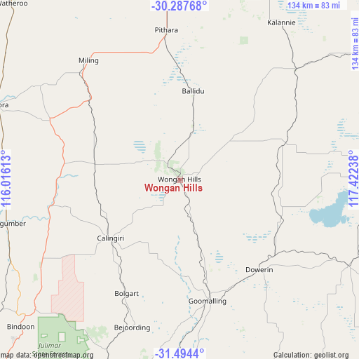
Wongan Hills GPS coordinates[2]
30° 53' 34.584" South, 116° 43' 9.3" East
| Map corner | latitude | longitude |
|---|---|---|
| Upper-left | -30.28768°, | 116.01613° |
| Center: | -30.89294°, | 116.71925° |
| Lower-right: | -31.4944°, | 117.42238° |
| Map W x H: | 134.2×134.2 km | = 83.4×83.4mi |
| max Lat: | -10.58257° ⇑29% North |
| Wongan Hills: | -30.89294° |
| min Lat: | ⇓71% South -43.31423° |
| min Long | Wongan Hills | max Long |
| 113.53327° | 116.71925° | 153.61246° |
| W 9.2%⇐ | ⇒90.8% E |
Elevation
Elevation of Wongan Hills is 291 m = 955 ft, and this is 169 m = 554 ft above average elevation for this country.
| Max E: |
1715 m = 5627 ft | 12.8% |
| Wongan Hills | 291 m 955 ft | |
| Avg. | 122 m = 400 ft | |
Min E: |
-2 m = -7 ft | 87.2% |
See also: Australia elevation on elevation.city.
Geographical zone
Wongan Hills is located in South temperate zone (between Tropic of Capricorn and the Antarctic Circle). Distance of this Southern Tropic circle is 829.1 km =515.2 mi to North.| Distance of | km | miles | from Wongan Hills |
|---|---|---|---|
| Equator | 3435 | 2134.4 | to North |
| Tropic Capricorn | 829.1 | 515.2 | to North |
| Antarctic Circle | 3966.2 | 2464.5 | to South |
| South Pole | 6572.1 | 4083.7 | to South |


Nearby cities:
15 places around Wongan Hills: (largest is in red/bold)
• Bakers Hill
98.1 km =61 mi,  194°
194°
• Bindoon
80.8 km =50.2 mi,  227°
227°
• Chittering
88.2 km =54.8 mi,  223°
223°
• Coondle
71.1 km =44.2 mi,  202°
202°
• Cunderdin
97.7 km =60.7 mi,  149°
149°
• Dalwallinu
68.3 km =42.4 mi,  355°
355°
• Gingin
92.6 km =57.5 mi,  236°
236°
• Goomalling
46.5 km =28.9 mi,  167°
167°
• Lower Chittering
95.8 km =59.5 mi, 216°
• Moora
73.9 km =45.9 mi,  292°
292°
• Morangup
95.4 km =59.3 mi,  205°
205°
• Northam
84.2 km =52.3 mi,  182°
182°
• Toodyay
76.9 km =47.8 mi, 198°
• West Toodyay
76.8 km =47.7 mi, 202°
• Wundowie
101.8 km =63.3 mi, 198°
Sources, notices
• [Note1] Compared only with cities in Australia existing in our database
• [Src1] Map data: © OpenStreetMap contributors (CC-BY-SA)
• [Src2] Other city data from geonames.org with taken over terms of usage.
• [Src3] Geographical zone / Annual Mean Temperature by Robert A. Rohde @ Wikipedia
