Katanning geodata
Katanning (Western Australia) is a populated place; located in Australia in Australia/Perth (GMT+8) time zone. With population of 3,655 people, there are 1935 cities with bigger population in this country. Compared to other cities in Australia, 51.5% of cities are located further ↓South; 90.3% of cities are located further →East and 87.9% of cities have lower elevation than Katanning. Note1


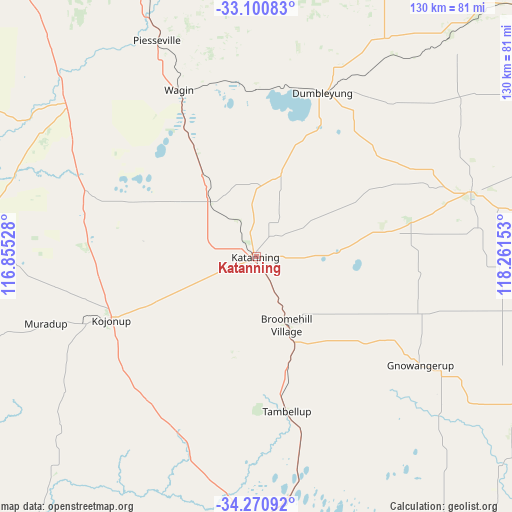
Katanning GPS coordinates[2]
33° 41' 16.332" South, 117° 33' 30.24" East
| Map corner | latitude | longitude |
|---|---|---|
| Upper-left | -33.10083°, | 116.85528° |
| Center: | -33.68787°, | 117.5584° |
| Lower-right: | -34.27092°, | 118.26153° |
| Map W x H: | 130.1×130.1 km | = 80.8×80.8mi |
| max Lat: | -10.58257° ⇑48.5% North |
| Katanning: | -33.68787° |
| min Lat: | ⇓51.5% South -43.31423° |
| min Long | Katanning | max Long |
| 113.53327° | 117.5584° | 153.61246° |
| W 9.7%⇐ | ⇒90.3% E |
Elevation
Elevation of Katanning is 309 m = 1014 ft, and this is 187 m = 614 ft above average elevation for this country.
| Max E: |
1715 m = 5627 ft | 12.1% |
| Katanning | 309 m 1014 ft | |
| Avg. | 122 m = 400 ft | |
Min E: |
-2 m = -7 ft | 87.9% |
See also: Australia elevation on elevation.city.
Geographical zone
Katanning is located in South temperate zone (between Tropic of Capricorn and the Antarctic Circle). Distance of this Southern Tropic circle is 1139.8 km =708.2 mi to North.| Distance of | km | miles | from Katanning |
|---|---|---|---|
| Equator | 3745.7 | 2327.5 | to North |
| Tropic Capricorn | 1139.8 | 708.2 | to North |
| Antarctic Circle | 3655.4 | 2271.4 | to South |
| South Pole | 6261.3 | 3890.6 | to South |


Nearby cities:
15 places around Katanning: (largest is in red/bold)
• Allanson
140.8 km =87.5 mi,  286°
286°
• Boddington
141 km =87.6 mi,  314°
314°
• Boyup Brook
109.4 km =68 mi,  261°
261°
• Bridgetown
134.9 km =83.8 mi, 256°
• Collie
134.9 km =83.8 mi, 285°
• Gnowangerup
50 km =31.1 mi,  123°
123°
• Kalgan
139.5 km =86.7 mi,  162°
162°
• Kendenup
88.5 km =55 mi,  176°
176°
• Kojonup
40.1 km =24.9 mi,  246°
246°
• Lake Grace
106.3 km =66.1 mi,  52°
52°
• Mount Barker
105.3 km =65.4 mi,  174°
174°
• Narrogin
91.1 km =56.6 mi,  337°
337°
• Pingelly
135.9 km =84.4 mi, 340°
• Wagin
46.6 km =29 mi,  334°
334°
• Williams
96.8 km =60.1 mi,  319°
319°
Sources, notices
• [Note1] Compared only with cities in Australia existing in our database
• [Src1] Map data: © OpenStreetMap contributors (CC-BY-SA)
• [Src2] Other city data from geonames.org with taken over terms of usage.
• [Src3] Geographical zone / Annual Mean Temperature by Robert A. Rohde @ Wikipedia
