Clare geodata
Clare (South Australia) is a populated place; located in Australia in Australia/Adelaide (GMT+10.5) time zone. With population of 3,223 people, there are 2113 cities with bigger population in this country. Compared to other cities in Australia, 53% of cities are located further ↑North; 81.1% of cities are located further →East and 90.4% of cities have lower elevation than Clare. Note1


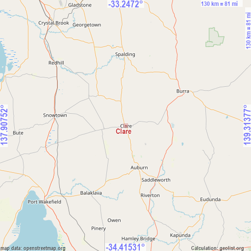
Clare GPS coordinates[2]
33° 49' 59.7" South, 138° 36' 38.304" East
| Map corner | latitude | longitude |
|---|---|---|
| Upper-left | -33.2472°, | 137.90752° |
| Center: | -33.83325°, | 138.61064° |
| Lower-right: | -34.41531°, | 139.31377° |
| Map W x H: | 129.9×129.9 km | = 80.7×80.7mi |
| max Lat: | -10.58257° ⇑53% North |
| Clare: | -33.83325° |
| min Lat: | ⇓47% South -43.31423° |
| min Long | Clare | max Long |
| 113.53327° | 138.61064° | 153.61246° |
| W 18.9%⇐ | ⇒81.1% E |
Elevation
Elevation of Clare is 390 m = 1280 ft, and this is 268 m = 879 ft above average elevation for this country.
| Max E: |
1715 m = 5627 ft | 9.6% |
| Clare | 390 m 1280 ft | |
| Avg. | 122 m = 400 ft | |
Min E: |
-2 m = -7 ft | 90.4% |
See also: Australia elevation on elevation.city.
Geographical zone
Clare is located in South temperate zone (between Tropic of Capricorn and the Antarctic Circle). Distance of this Southern Tropic circle is 1156 km =718.3 mi to North.| Distance of | km | miles | from Clare |
|---|---|---|---|
| Equator | 3761.9 | 2337.5 | to North |
| Tropic Capricorn | 1156 | 718.3 | to North |
| Antarctic Circle | 3639.3 | 2261.4 | to South |
| South Pole | 6245.2 | 3880.6 | to South |


Nearby cities:
15 places around Clare: (largest is in red/bold)
• Auburn
22.6 km =14 mi,  162°
162°
• Balaklava
39.3 km =24.4 mi,  207°
207°
• Burra
34.4 km =21.4 mi,  58°
58°
• Crystal Brook
65.1 km =40.5 mi,  325°
325°
• Eudunda
58 km =36 mi,  131°
131°
• Freeling
71.4 km =44.4 mi,  165°
165°
• Gladstone
67.2 km =41.8 mi,  339°
339°
• Hamley Bridge
58.7 km =36.5 mi, 173°
• Jamestown
69.8 km =43.4 mi,  359°
359°
• Kapunda
62.9 km =39.1 mi,  153°
153°
• Mallala
67.8 km =42.1 mi,  187°
187°
• Port Broughton
67.5 km =41.9 mi,  292°
292°
• Port Wakefield
58 km =36 mi,  227°
227°
• Riverton
38 km =23.6 mi, 160°
• Wasleys
71.1 km =44.2 mi, 174°
Sources, notices
• [Note1] Compared only with cities in Australia existing in our database
• [Src1] Map data: © OpenStreetMap contributors (CC-BY-SA)
• [Src2] Other city data from geonames.org with taken over terms of usage.
• [Src3] Geographical zone / Annual Mean Temperature by Robert A. Rohde @ Wikipedia
